Pricing Change
New pricing for orders of material from this site will come into place shortly. Charges for supply of digital images, digitisation on demand, prints and licensing will be altered.
Upcoming Maintenance
Please be advised that this website will undergo scheduled maintenance on the following dates:
Thursday, 30 January: 11:00 AM - 3:00 PM
During these times, some functionality such as image purchasing may be temporarily unavailable. We apologise for any inconvenience this may cause.
Lanark Castle
Castle (Medieval), Coin(S) (Roman)
Site Name Lanark Castle
Classification Castle (Medieval), Coin(S) (Roman)
Alternative Name(s) Castle Hill
Canmore ID 46574
Site Number NS84SE 13
NGR NS 8792 4331
Datum OSGB36 - NGR
Permalink http://canmore.org.uk/site/46574
- Council South Lanarkshire
- Parish Lanark
- Former Region Strathclyde
- Former District Clydesdale
- Former County Lanarkshire
NS84SE 13.00 8792 4331.
NS84SE 13.01 NS 87 43 Watching Brief; Trial Excavations
(NS 8792 4331) Lanark Castle (NR) (site of)
OS 6" map (1968)
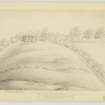
No traces now remain of this castle, which stood on Castle Hill, a small prominent knoll. The summit is now a bowling green and the sides gardens.
Name Book 1860
The large and important castle of Lanark was a royal fortress in the time of David I. All that now marks the site is the mound on which the keep stood. Coins of Edward I (1272-1307) have been found, as well as a silver Faustina but this, as well as other Roman coins found in adjacent fields, cannot be taken as proof of a Roman occupation, in spite of Roy's assertion to the contrary.
W Roy 1793; G V Irving and A Murray 1864
Castle Hill is of artificial appearance, probably consisting of a natural hill scarped to form a motte 7.5m high. There is a causewayed entrance to the E. The hill is in a commanding position, with precipitous slopes to the W. The site is mutilated by a bowling green on top of the mound.
Visited by OS (JFC) 25 March 1955
Listed as a motte.
E Talbot 1974
The steep-sided promontory of Castle Hill, the site of a medieval stronghold, is clearly an unsuitable location for a Roman fort, although the discovery here of Roman coins, including a denarius of Faustina, may indicate native occupation in the Roman period.
RCAHMS 1978
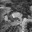
Lanark Castle is situated on a natural hill, which in all probability was scarped during the building of the castle. The base of the hill now has a diameter of about 90m and the summit about 50m. The castle would have had considerable natural protection because of the precipitous slopes especially on the S and W sides, much of which is now wooded.
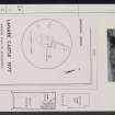
The flat summit is now (and has been for two centuries) a bowling green with three associated buildings. As a new club house was to be built, a small rescue excavation (of an area measuring 15 by 6m - see plan) was carried out in 1977 by members of Lanark Archaeological Society for the Department of the Environment (DoE).
The royal castle seems to have existed in the time of David I (1124-53) and was perhaps built on the site of an earlier fort. By the late 13th century the castle may no longer have been occupied but instead used as a prison. However, the Scots parliament is known to have met at the castle in 1293, 1294 and 1295. In 1310 Robert I gained possession of the town and castle, but it is not known to what use he put the latter. After the removal of turf, modern path material and top soil, a thick layer of yellow sand was encountered; this was most probably used during the laying of the bowling green. Below this was a layer of burnt material - a succession of thin turf layers and intermediate layers of silty material containing charcoal and patches of burnt clay. The pieces of charcoal were all of small diameter and unlikely to have been from structural timbers or from a palisade. The burnt material was probably formed by regular burning of the hillside to destroy heather and gorse to facilitate the growth of pasture for grazing animals. This may have happened during or after the occupation of the castle. Near the bottom of the burnt material were two areas of flat stones, which could have formed a path at one time. Associated with these stones were a few small nails and the only two pieces of stratified pottery on the site. These were of 12th - 13th century date. (Other, unstratified sherds were possibly of 14th century date, though the majority dated from the 17th - 18th century.) Underlying the burnt material was natural, undisturbed clay.
It is likely that the area of the mound summit has been extended during the laying of the bowling green, implying that any palisade trench and associated structures were some distance W of the present slope and hence not in the area excavated.
J H Lewis 1978
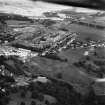
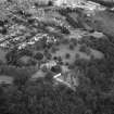
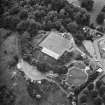
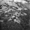
Photographed by the RCAHMS in 1980.
Excavation (1977)
Lanark Castle is situated on a natural hill, which in all probability was scarped during the building of the castle. The base of the hill now has a diameter of about 90m and the summit about 50m. The castle would have had considerable natural protection because of the precipitous slopes especially on the S and W sides, much of which is now wooded.
The flat summit is now (and has been for two centuries) a bowling green with three associated buildings. As a new club house was to be built, a small rescue excavation (of an area measuring 15 by 6m - see plan) was carried out in 1977 by members of Lanark Archaeological Society for the Department of the Environment (DoE).
The royal castle seems to have existed in the time of David I (1124-53) and was perhaps built on the site of an earlier fort. By the late 13th century the castle may no longer have been occupied but instead used as a prison. However, the Scots parliament is known to have met at the castle in 1293, 1294 and 1295. In 1310 Robert I gained possession of the town and castle, but it is not known to what use he put the latter. After the removal of turf, modern path material and top soil, a thick layer of yellow sand was encountered; this was most probably used during the laying of the bowling green. Below this was a layer of burnt material - a succession of thin turf layers and intermediate layers of silty material containing charcoal and patches of burnt clay. The pieces of charcoal were all of small diameter and unlikely to have been from structural timbers or from a palisade. The burnt material was probably formed by regular burning of the hillside to destroy heather and gorse to facilitate the growth of pasture for grazing animals. This may have happened during or after the occupation of the castle. Near the bottom of the burnt material were two areas of flat stones, which could have formed a path at one time. Associated with these stones were a few small nails and the only two pieces of stratified pottery on the site. These were of 12th - 13th century date. (Other, unstratified sherds were possibly of 14th century date, though the majority dated from the 17th - 18th century.) Underlying the burnt material was natural, undisturbed clay.
It is likely that the area of the mound summit has been extended during the laying of the bowling green, implying that any palisade trench and associated structures were some distance W of the present slope and hence not in the area excavated.
J H Lewis 1978
Publication Account (1981)
Little is known of the royal castle at Lanark. The existence of a sheriff at Lanark in 1165 x 1171 (Barrow, 1971, 64) implies that a castle was at the burgh in the reign of William the Lion. Lanark Castle was among several included in Queen Johanna's dowry of 1221. It might well have been derelict at an early stage. A.D.Robertson believes the buildings to have been destroyed by the end of the thirteenth century for in a list drawn up in 1296 of all the Scottish royal castles with English governors, Lanark Castle was not mentioned (1974, 44). The Castlehill occupies a commanding position. Recent excavations there indicate that the mound is definitely natural although artificially scarped.
Information from ‘Historic Lanark: The Archaeological Implications of Development’ (1981).


