
Dalmellington, Waterside Ironworks, Bing


Bing (Period Unassigned)
Site Name Dalmellington, Waterside Ironworks, Bing
Classification Bing (Period Unassigned)
Alternative Name(s) Dalmellington Iron Works, Slag-hill; Dalmellington, Waterside Ironworks Complex; Waterside Bing
Canmore ID 124123
Site Number NS40NW 15.03
NGR NS 4388 0828
NGR Description NS c. 4388 0828
Datum OSGB36 - NGR
Permalink http://canmore.org.uk/site/124123


- Council East Ayrshire
- Parish Dalmellington
- Former Region Strathclyde
- Former District Cumnock And Doon Valley
- Former County Ayrshire
NS40NW 15.03 4388 0828.
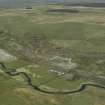
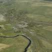
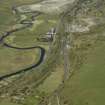
The monument comprises an impressive iron slag bing which contains an estimated 1,470,000 tonnes of ironstone slag and reaches 30m high. It was formed as an essential by-product of the operation of the former Dalmellington Ironworks.
This waste material helps chart the stages of technological development in smelting iron at Dalmellington from 1850-1920; the lower layer containing slag material from the manufacture of common iron and the upper layer composed of waste from the production of haematite iron. The bing was extended to the W in 1915 following the diversion of the River Doon and was regraded at the E and N in 1986/87.
Information from Historic Scotland, scheduling document dated 30 September 1997.

