
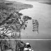
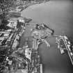
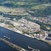
Greenock, Great Harbour


Dock (19th Century) - (20th Century)
Site Name Greenock, Great Harbour
Classification Dock (19th Century) - (20th Century)
Alternative Name(s) Garvel Embankment; Greeenock, Docks; Greenock Harbour
Canmore ID 68402
Site Number NS37NW 18
NGR NS 30304 75600
Datum OSGB36 - NGR
Permalink http://canmore.org.uk/site/68402


- Council Inverclyde
- Parish Greenock
- Former Region Strathclyde
- Former District Inverclyde
- Former County Renfrewshire
NS37NW 18.00 30304 75600
Great Harbour [NAT] (centred NS 3025 7562)
OS 1:2500 map, 1968.
NS37NW 18.01 Centred NS 30085 75795 East Jetty
NS27NW 18.02 Centred NS 30400 75690 Tanker cleaning installation and pier
See also:
NS27NE 17.00 NS 29677 75697 James Watt Dock
NS27NE 31.00 NS 29337 75925 Garvel Wet Dock
NS27NE 31.01 NS 29531 75888 Garvel Dry Dock
Location formerly entered as NS 302 756.
'Great Harbour (1880 on)... engineer W R Kinipple'.
J R Hume 1976.
Visible on vertical air photographs (OS 88/041/098, flown 1988).
(Undated) information in NMRS.
Note (6 June 2017)
The Great Harbour was part of a large late-19th century scheme to create a massive harbour to compete against the Glasgow Docks. The scheme was not successful and the Great Harbour part was never completed to the scale of the original plan. Much of the spoil from the James Watt dock was used to create an island called the East Jetty (see NS37NW 18.1) and a quay along the former shore line at Ladyburn (NS37NW 17.1).
Information from HES, Survey and Recording (AKK) 2 April 2017.

