
Scheduled Maintenance
Please be advised that this website will undergo scheduled maintenance on the following dates: •
Tuesday 3rd December 11:00-15:00
During these times, some services may be temporarily unavailable. We apologise for any inconvenience this may cause.
Clyde Defences, Dunoon, Castle Gardens, Dunoon Battery


Anti Aircraft Battery (Second World War), Coastal Battery (Second World War), Searchlight Battery (Second World War), Searchlight Battery (First World War)
Site Name Clyde Defences, Dunoon, Castle Gardens, Dunoon Battery
Classification Anti Aircraft Battery (Second World War), Coastal Battery (Second World War), Searchlight Battery (Second World War), Searchlight Battery (First World War)
Canmore ID 106362
Site Number NS17NE 26
NGR NS 1751 7637
Datum OSGB36 - NGR
Permalink http://canmore.org.uk/site/106362


- Council Argyll And Bute
- Parish Dunoon And Kilmun
- Former Region Strathclyde
- Former District Argyll And Bute
- Former County Argyll
War Office files for the defences of the River Clyde show that there were two Defence Electric Lights (DELs, large searchlights intended to illuminate targets for coast guns at night) at Dunoon, in place by January 1917 (The National Archives WO 78/5182). They were still in use in the Second World War, when there was also a 12-pdr gun at Dunoon (recorded in January 1940). The anti-submarine boom (see NS27NW 137 - a heavy net to prevent submarines entering the port) was stretched between Dunoon and Cloch Point.
Information from HS/RCAHMS World War One Audit Project (GJB) 4 July 2013.
NS17NE 26 1751 7637
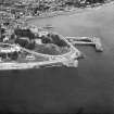
This World War II coastal battery is situated within the grounds surrounding Dunoon Castle.
Only a few sections of the foundations could be located on the date of visit whilst other buildings used by the battery crew are still extant.
The battery mounted 1 12 pounder MkI, gun number 1343, which was installed during February 1940. The gun was removed during September 1945. The battery was constructed to protect the anti-submarine boom between Dunoon and Gourock. (information from PRO document WO/192/245)
J Guy 2001; NMRS Part 1, 52-3
The coast battery was armed with a 12pdr QF gun (quick firing) the mounting for which which stood where the crazy golf course is now located. On the summit of the Castle Motte are the ruins of where a static 40mm Bofors gun was installed (63feet above 12 pdr).
Information from Defence of Britain Project recording form, July 1997
Project (March 2013 - September 2013)
A project to characterise the quantity and quality of the Scottish resource of known surviving remains of the First World War. Carried out in partnership between Historic Scotland and RCAHMS.
Field Visit (21 October 2016)
Nothing now remains of two searchlights (NS 17540 76295) that once stood close together on the waterfront at Dunoon and supported the use of the anti-submarine net that was strung between there and Cloch Point in World War One. A1927 Aerofilm photograph shows that the searchlights (and the buildings they were housed in) had been removed by that time. The Fort Record Book (National Archives: WO 192/245) contains little detail of the early use of the site but it does contain a sketch map of the gun battery that was in use in the Second World War. The searchlights used in the Second World War were not the same searchlights and, as with their earlier counterparts, nothing of them is now visible in an area currently occupied by a small crazy golf course.
Except for a length of concrete wall on the northern edge of the summit of Castle Hill, nothing is now visible of any of the installations that once stood there. In addition to the 12-pound gun, these were a Battery Observation Post (B.O.P.), a store, a magazine and a war shelter. Other buildings within the battery included two ‘Sleeping Accommodation’ huts (NS 17422 76323 and NS 17440 76352), which stood SW of Castle Hill, immediately W and NW respectively of a building containing public conveniences (NS17NE 115). Another structure, noted as a ‘Cookhouse’ on the plan, was built against the N face of the conveniences. Nothing can now be seen of these three structures.
Similarly, nothing is now visible at the foot of the W flank of the hill of either the ‘Main Magazine’ or the ‘Oil and Petrol Store’. The only building that was part of the battery (though pre-dating it) and still survives is the waterfront cafe (NS 17578 76355), which is noted as being a ‘Store and Office’.
Visited by HES Survey and Recording (JRS) 21 October 2016.

