
Pricing Change
New pricing for orders of material from this site will come into place shortly. Charges for supply of digital images, digitisation on demand, prints and licensing will be altered.
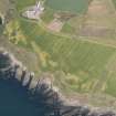
Kames


Standing Stone(S) (Prehistoric)
Site Name Kames
Classification Standing Stone(S) (Prehistoric)
Alternative Name(s) Kames, Ann Terrace
Canmore ID 39886
Site Number NR97SE 1
NGR NR 9717 7137
Datum OSGB36 - NGR
Permalink http://canmore.org.uk/site/39886


- Council Argyll And Bute
- Parish Kilfinan
- Former Region Strathclyde
- Former District Argyll And Bute
- Former County Argyll
NR97SE 1 9717 7137
Visited by OS (IA) 27 October 1972.
NR 9710 7130 An archaeological watching brief was undertaken on 8 February 2007 at a site at Ann Terrace in Kames
in advance of a proposed residential development. No significant archaeological features or artefacts were encountered.
Archive to be deposited with RCAHMS.
Funder: Forbes and Adam.
Alan Duffy, 2007.
Field Visit (17 September 1942)
This site was included within the RCAHMS Emergency Survey (1942-3), an unpublished rescue project. Site descriptions, organised by county, vary from short notes to lengthy and full descriptions and are available to view online with contemporary sketches and photographs. The original typescripts, manuscripts, notebooks and photographs can also be consulted in the RCAHMS Search Room.
Information from RCAHMS (GFG) 10 December 2014.
Field Visit (October 1984)
There are three standing stones at the crossroads in Kames, one in a railed enclosure beside the War Memorial, the other two 39m to the N, partly embedded in a bank and a hedge on the opposite side of the road (Childe and Graham 1943, 34; Henshall 1972, 367). The S stone, in the enclosure, measures 1.2m by 0.45m at the base and rises in an equal gable to a pointed top at a height of 1.45m. The larger stone of the pair to the N measures 2.8m in height and 1.9m by 0.4m at the base; it rises with straight sides to a slanting top. The smaller stone, about 1m to to the N, is about 2m in girth at the point where it protrudes from the bank, and is at least 1.5m high; quadrangular on plan, it is aligned roughly N and S. The pair of stones has been interpreted as the portal stones of a chambered cairn, the remainder of which has been destroyed, but there is no evidence to support this.
RCAHMS 1988, Visited October 1984.
Measured Survey (10 October 1984)
RCAHMS surveyed Kames standing stones on 10 October 1984 with plane-table and alidade producing a plan at a scale of 1:100. The plan of the standing stones was redrawn in ink and published at a scale of 1:250 (RCAHMS 1988a, 135).
Archaeological Evaluation (8 February 2007)
NR 9710 7130 An archaeological watching brief was undertaken on 8 February 2007 at a site at Ann Terrace in Kames in advance of a proposed residential development. No significant archaeological features or artefacts were encountered.
Archive to be deposited with RCAHMS.
Funder: Forbes and Adam.

