
Stonehaven, Plague Burials


Burial Ground (Early 17th Century), Gravestone(S) (Early 17th Century) (1608)
Site Name Stonehaven, Plague Burials
Classification Burial Ground (Early 17th Century), Gravestone(S) (Early 17th Century) (1608)
Canmore ID 36909
Site Number NO88NE 3
NGR NO 87400 85510
Datum OSGB36 - NGR
Permalink http://canmore.org.uk/site/36909


- Council Aberdeenshire
- Parish Dunnottar
- Former Region Grampian
- Former District Kincardine And Deeside
- Former County Kincardineshire
NO88NE 3 8740 8551 to 8741 8552.
(NO 8740 8551) Burial Ground (NR) (Plague of 1608-1648)
OS 1/500 plan, (1864)
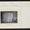
About 1842 two gravestones which had lain on a piece of waste ground were erected against a bank on the left of the path opposite the Bog Well.
One bore the inscription ".. Magnus Tailiour Seyman ... depairtit in November - ... of Pest ... Memento Mori 1608". The other commemorated two children who died in 1648, also of plague.
New Statistical Account (NSA) 1845; Name Book 1864; F C Eeles 1897.
The gravestones are now set in, and form part of, the east wall of a public footpath at NO 8741 8552.
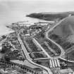
The site of the burial ground on the OS plan is now occupied by modern buildings and gardens.
Surveyed at 1/2500.
Visited by OS (R D) 23 July 1965.

