
Pricing Change
New pricing for orders of material from this site will come into place shortly. Charges for supply of digital images, digitisation on demand, prints and licensing will be altered.
The Nine Stanes, Garrol


Recumbent Stone Circle (Neolithic) - (Bronze Age), Ring Cairn (Neolithic) - (Bronze Age)
Site Name The Nine Stanes, Garrol
Classification Recumbent Stone Circle (Neolithic) - (Bronze Age), Ring Cairn (Neolithic) - (Bronze Age)
Alternative Name(s) Garrol Wood; Garrol Hill; Mulloch Wood; Nine Stones
Canmore ID 36748
Site Number NO79SW 8
NGR NO 72331 91219
Datum OSGB36 - NGR
Permalink http://canmore.org.uk/site/36748


- Council Aberdeenshire
- Parish Banchory-ternan
- Former Region Grampian
- Former District Kincardine And Deeside
- Former County Kincardineshire
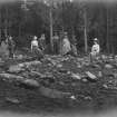
Field Visit (March 1984)
NO79SW 8 7233 9122.
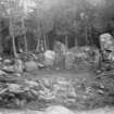
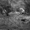
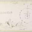
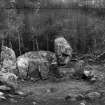
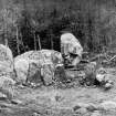
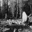
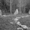
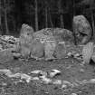
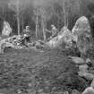
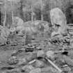
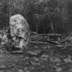
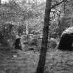
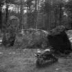
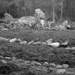
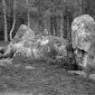
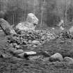
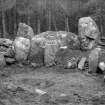
This recumbent stone circle and ring-cairn are situated in a forestry clearing 650m NW of Garrol farmhouse. The stone circle is oval, measuring 17.5m from ENE to WSW by 14.5m transversely, and, in addition to the recumbent and its flankers, comprised eight uprights, one of which is missing and another reduced to a stump. The recumbent (2.5m by 1.8m and 1m in height) lies on the SSE, both on the line of the circle, which is markedly flattened at this point, and the perimeter of the ring-cairn. The W flanker measures 1m by 0.9m at the base and 2m in height and the E flanker, which is fallen, 0.8m by 0.5m and 1.8m in length. The stones of the circle appear to be set into a low bank 2m thick and 0.3m high; on the E they are graded in height (ranging from 1.5m on the E to 1.1m on the N) but are not so on the W. The ring-cairn measures 12m in diameter by 0.3m in height and there is a hole 4.3m in diameter by 0.4m in depth at its centre. Excavation in 1904 revealed two concentric inner kerbs (the longer c. 4.3m in diameter and the smaller c. 4m); within the central area there was a funnel-shaped pit which contained charcoal and cremated bone, and a round the pit there were four deposits of cremated bone and one of charcoal mixed with pottery.
RCAHMS 1984, visited March 1984.
(Name Book 1864; R A Smith 1880; F R Coles 1900; F R Coles 1905; A Thom, A S Thom and A Burl 1980)
Publication Account (1986)
Lichen covered and grey amongst the larches, this recumbent stone circle is in a classic position, on a hill shelf with broad views to the south and west. In plan, however, it differs from early circles like East Aquhorthies (no. 100), Sunhoney (no. 99) or Castle Fraser (N] 714125) in being a 'flattened circle', 18m by 14.6m, with the mossy recumbent and flankers on the straighter side. One flanker has fallen but six other standing stones of medium height remain. The ring cairn within the circle runs against the squat recumbent, and still bears evidence of a 19th century 'excavation' which found cremated bone.
Information from ‘Exploring Scotland’s Heritage: Grampian’, (1986).
Publication Account (1996)
Lichen covered and grey amongst the larches, this recumbent stone circle is in a classic position, on a hill shelf with broad views to the south and west. In plan, however, it differs from early circles like East Aquhorthies (no. 100), Sunhoney (no. 99) or Castle Fraser (NJ 714125) in being a 'flattened circle', 18m by 14.6m, with the mossy recumbent and flankers on the straighter side. One flanker has fallen but six other standing stones of medium height remain. The ring cairn within the circle runs against the squat recumbent, and st ill bears evidence of a 19th century 'excavation' which found cremated bone.
Information from ‘Exploring Scotland’s Heritage: Aberdeen and North-East Scotland’, (1996).
Field Visit (11 June 2003)
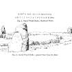
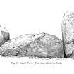
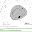
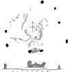
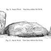
Standing within a clearing in Mulloch Wood, this is one of the best-known recumbent stone circles, though its location on the N side of the saddle between Mulloch Hill and Garrol Hill is largely hidden by the trees. Known as The Nine Stanes, its name is a misnomer, acquired some time after the removal of one of the orthostats on the NW (8) and the reduction of another to a stump (9); its true complement was eleven. The recumbent setting forms the centrepiece of a flattened façade on the SE of the circle, which measures roughly 18.5m from NE to SW by 15.5m transversely. Slewed round to face SE, the recumbent (2) is a block measuring 2.55m in length by 1.25m in height and its uneven summit dips towards the centre. The flankers are of a similar size and shape, and the western (1) stands 1.9m high as compared with a length of 2.05m for its fallen neighbour on the E (3). The western, however, is set markedly askew to the axis of the recumbent and turned as if to pick up the circumference of the internal cairn rather than that of the ring of orthostats. Six orthostats remain upright (4–7 and 10–11), while the stump on the WNW (9) is fractured into three pieces; the latter and the socket of the missing stone on the NW (8) were revealed by excavations carried out in 1904 by Coles. Set out along the lip of a low stony platform, the stones on the E are consistently graded to reduce in height and spacing from S to N, the shortest being 1m high on the NNE (6); this pattern is not so clear on the W, where the stones are more evenly spaced and orthostat 11 on the SW is shorter than either of its neighbours. On the ENE the lip of the platform rises into a low bank, though whether this is an original feature or the result of restoration following Coles’ excavations is unknown. Around most of the circumference he uncovered ‘a double row of smallish earth-fast stones’ (1905, 200) and in some places the gap between them was filled in with smaller stones. While he concluded that this was the remains of an old dyke, he advanced no evidence to determine its stratigraphical relationship to the orthostats standing along its line (ibid, 193, fig 1); it is as likely to be an ancient component of the circle.
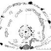
Within the interior there is a low mound measuring 12.5m from E to W by 11m transversely and 0.25m in height. Completely excavated by Coles, this measures about 12.8m in diameter on his plan over a near continuous kerb of rough boulders that increased in size towards the recumbent setting, though it followed an unusual and irregular course on the SE; only twelve of the kerbstones are now visible, all bar one on the W side of the cairn. At its centre there was a court, bounded by two rings of kerbstones, which he depicted concentrically, set little more than 0.15m apart. Coles measured the diameter of the larger at 3.8m within an intermittent ring of squat boulders about 0.3m high. Measured from the plan, the smaller was 3.1m in diameter, and it had been furnished with a kerb of much taller close-set slabs up to 1.1m high, though most of them had been robbed, leaving one upright, another leaning, and six lying on the floor. The single stone now visible belongs to the SE arc of this taller ring. At face value, these two kerbs probably represent successive phases of construction, and with two stones of the smaller, inner ring still in their sockets when Coles commenced his excavation, this was probably the later. Five deposits of burnt bones were found within this court: one filled a stone-lined, funnel-shaped pit some 0.65m in diameter by 0.25m in depth at the centre; three were in shallow hollows scooped into the subsoil (on the SE, S and SW respectively); and the fifth lay on a flat stone on the NW. Sherds of coarse pottery were found in a separate deposit on the NNE (NMAS EP 25). The stratigraphic relationships of these various deposits are uncertain.
Visited by RCAHMS (ATW and KHJM) 11 June 2003
Measured Survey (11 June 2003)
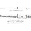
RCAHMS surveyed The Nine Stanes recumbent stone circle on 11 June 2003 with plane table and alidade producing a plan and sections of the site and an elevation of the recumbent setting at a scale of 1:100. The plan, sections and elevation were used as the basis for an illustration, produced in ink and finished in vector graphics software, that was published at a scale of 1:250 (Welfare 2011, 413).
Archaeological Evaluation (18 December 2019 - 21 December 2019)
NO 72330 91223 An assessment was undertaken within the Scheduled Monument called The Nine Stanes, Mulloch Wood, Stone Circle (SM979, Canmore ID: 36748) on behalf of Forestry and Land Scotland in relation to two recently windblown trees located immediately to the E of the stone circle within the Scheduled Area. The purpose of the work was to assess whether the uprooting of the two trees had caused any damage to buried archaeological remains, and the assessment was carried out between 16 December and 21 December 2019. The work comprised excavation of a single trench incorporating the two tree root bowls and an area to the SW next to the outer edge of the stone circle. Although excavation was limited, this extension allowed comparison of deposits encountered at the windblow site with those on the fringes of the stone circle, while also providing an opportunity to re-examine an area thought to have been excavated in the early 1900s by F Coles.
Overall there had been minimal disturbance to buried archaeological remains as a result of the two windblown trees, although a very small portion of a possible trampled surface that was present around the outside edge of the stone circle may have been partially disturbed. In addition to the trampled surface a small, truncated cairn was recorded to the E of the standing stones while the origins of a large cairn-like deposit of earth and stone, defined on its eastern side by a possible narrow gully running between the fallen flanker and an upright stone to the NE, remains unclear. This material could relate to the ephemeral remains of a larger cairn within the stone circle or be the result of backfill and reinstatement from the 1904 excavation.
Archive: NRHE
Funder: Forestry and Land Scotland
Steven Black – Clyde Archaeology
(Source: DES Vol 21)
OASIS ID: clydearc1-389583

