
Pricing Change
New pricing for orders of material from this site will come into place shortly. Charges for supply of digital images, digitisation on demand, prints and licensing will be altered.
Arbuthnott House, Avenue


Tree Avenue (17th Century)
Site Name Arbuthnott House, Avenue
Classification Tree Avenue (17th Century)
Alternative Name(s) Arbuthnott House, Dark Avenue; Arbuthnott House Policies
Canmore ID 140111
Site Number NO77NE 70
NGR NO 7900 7535
NGR Description Centred NO 7900 7535
Datum OSGB36 - NGR
Permalink http://canmore.org.uk/site/140111


- Council Aberdeenshire
- Parish Arbuthnott
- Former Region Grampian
- Former District Kincardine And Deeside
- Former County Kincardineshire
NO77NE 70 centred 7900 7535
See also NO77NE 2.00
Site recorded during a pre-afforestation survey undertaken of c 230ha of land, divided into numerous compartments around Arbuthnott House..
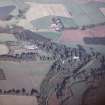
NO 7900 7535 Tree-lined avenue.
Sponsor: Historic Scotland
Holden 1998
This tree-lined avenue is situated on a moderate SE-facing slope at an altitude of about 85m OD. It measures 250m in length by 40m transversely and forms part of the 'Dark Avenue' in the designed landscape within the grounds of Arbuthnott House (NO77NE 2.00).
NMRS, MS/712/38.

