
Pricing Change
New pricing for orders of material from this site will come into place shortly. Charges for supply of digital images, digitisation on demand, prints and licensing will be altered.
Upcoming Maintenance
Please be advised that this website will undergo scheduled maintenance on the following dates:
Thursday, 9 January: 11:00 AM - 3:00 PM
Thursday, 23 January: 11:00 AM - 3:00 PM
Thursday, 30 January: 11:00 AM - 3:00 PM
During these times, some functionality such as image purchasing may be temporarily unavailable. We apologise for any inconvenience this may cause.
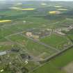
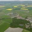
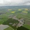
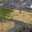
Edzell Airfield


Airfield (20th Century)
Site Name Edzell Airfield
Classification Airfield (20th Century)
Alternative Name(s) Raf Edzell; Comsecgru Two; United States Naval Security Group Activity Edzell; Bridgend
Canmore ID 88956
Site Number NO66NW 75
NGR NO 631 691
NGR Description Centred NO 631 691
Datum OSGB36 - NGR
Permalink http://canmore.org.uk/site/88956


- Council Aberdeenshire
- Parish Fettercairn
- Former Region Grampian
- Former District Kincardine And Deeside
- Former County Kincardineshire
NO66NW 75.00 centred 631 691
For northern dispersals (centred NO 6158 7037 and 6268 7085), see NO67SW 33.
See also NO66NW 81.
NO66NW 75.01 NO 6204 6985 and NO 6268 7085 northern hangar area
NO66NW 75.02 NO 6241 6903, 6255 6910 and 6250 6925 southern hangar area
NO66NW 75.03 NO 6375 6953 to NO 6402 6894 eastern dispersals
NO66NW 75.04 NO 6333 6860 to NO 6347 6785 southern dispersals
NO66NW 75.05 centred NO 6235 6918 accommodation and administration area
NO66NW 75.06 centred NO 6215 6940 married quarters area
NO66NW 75.07 NO 6208 6981 W F Halsey School
NO66NW 75.08 NO 6310 6881 and NO 6344 6910 communications intercept station
NO66NW 75.09 NO 6340 6878 Pillbox
NO66NW 75.10 NO 6376 6908 Pillbox
NO66NW 75.11 NO 6354 6919 Pillbox
NO66NW 75.12 NO 6263 6837 Pillbox
RAF Edzell [NAT]
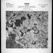
OS 1:10,000 map, 1977.
World War II: no longer used for flying, but still used by RAF. Visible on air photograph AAS/94/05/G12/8, flown 24 February 1994. Copies held in Grampian Region SMR.
NMRS, MS/712/6 and MS/712/21.
During 1995, the US Government announced that the Edzell base would be run down and will close over the next year.
Information from RCAHMS (DE) February 1996
This air station was visited in the course of decommissioning, operations having ceased in September 1996 and final closure being scheduled for 30 September 1997. Locked doors prevented access to some buildings. Building numbers cited in this report refer to the plan (NMRS DC35998) supplied by the station staff in the course of fieldwork.
The most recent use of the station as a (highly-specialised) strategic communications intercept facility under the titles Comsecgru Two and United States Navy (USN) Security Group Facility Edzell makes it unparalleled in Scotland, although there are comparable (and presumably associated) installations (at Menwith Hill, Yorks. and Chicksands, Beds.) in England.
Taken as a whole, the station presents a picture of a near-standard wartime fixed (training and maintenance) station, having a wide range of standard (wartime utilitarian) RAF buildings. The unusual plan of this two- (rather than the more normal three-) runway airfield may have been resulted from the need to avoid marshy ground in Shepherd?s Wood and Cleary Wood (around NO 630 680).
The period of use by the United States Navy (not National Security Agency, as stated by Smith) has seen: a high standard of maintenance (including partial re-cladding of the hangars), the construction of additional accommodation and of some specifically American facilities (including baseball courts), and the construction of specific-to-role operations facilities and radio antennae.
The station may be considered in two sections, which are separated by security fencing:
1. Administration and Accommodation area (including administration block, hangars, bachelor enlisted quarters, married quarters and school) in the NW part of the base and alongside the public road,
2. Operations area (including operations and related buildings, antenna array, radomes, runways and taxiways) occupying by far the greater part of the area of the base.
Vertical air photography (106G/SCOT/UK/62 3028-33, flown 8 May 1946) has recorded the use of the airfield for maintenance (and possibly scrapping) at that date, aircraft of various types being parked both on the airfield and across the public road to the W (around NO 621 687). No control tower is evident but a (since-demolished) hut alongside the signal square has a raised portion at one end and presumably served as a combined watch office and control/signal tower. The perimeter track and both runways appeared to be serviceable and in good condition at the date of imagery, but the signal square (NO 626 691) indicates that the airfield is unserviceable (except for the runways) and subject to temporary obstruction; there is no runway caravan or other evidence of current activity and the code letters for the airfield are 'EZ'. Ground defence and/or anti-glider trenches can be identified in some parts of the operating area and there are traces of camouflage paint on the NE/SW runway. The circular feature (of diameter 110m) that is depicted on the 1977 edition of the OS 1:10,000 map around NO 6380 6855) cannot be identified.
The accommodation and administration area presents an appearance typical of second-line airfields of this period. No officers? mess, station headquarters or station commander's house can be distinguished and there were no married quarters at this date, but the water tower and boiler house are evident in vertical elevation. Unusually, there is no parachute packing or storage building and no specific training facilities can be identified. The apparent absence of these facilities is consistent with the construction of the airfield as a specialist maintenance unit.
Visited by RCAHMS (RJCM), 13 August 1997.
NMRS, DC35998.
Air photographs: AAS/97/03/G4/19-23, AAS/97/03/CT, AAS/97/07/G13/10-11 and AAS/97/07/CT.
NMRS, MS/712/29.
Examination of photographic copies of a series of World War II vertical and oblique aerial views of the airfield reveal the transition from grass to concrete runways. The earliest taken on the 15th August 1940 show the airfield in the final stages of completion with a grass runway area. Also visible are a camouflaged group of three J or K type aircraft hangars, with further examples dispersed, complete or nearing completion. The technical area with buildings and huts and other ancilliary structures are also in place. A further frame from 7 June 1942 shows that a perimeter track and main runway had been completed along with some new dispersed areas. The image from 11 April 1944 reveals extensive re-construction of two main runways which lie at right angles to one another, new dispersals with 'blister' hangars and a star -shaped concrete dispersal area (Steelstrath). By this date the perimeter track is complete with what may be additional L type aircraft hangars. A small aircraft diuspersal area has also been created to the SW near to Dalladies farmstead. Though not visible on the 1944 image, further extension of the airfield is apparent from the OS maps to the W of the minor road from North Water Birdge to the junction with the B966 road.
Information from RCAHMS (DE), June 2010

