Accessibility

Font Size

100% 150% 200%

Background Colour

Default Contrast
Close Reset

Inchbare North

Pit(S) (Period Unknown), Pit Alignment(S) (Prehistoric), Pit Defined Cursus (Neolithic), Rig And Furrow (Medieval) - (Post Medieval), Ring Ditch(S) (Prehistoric)(Possible), Unenclosed Settlement (Prehistoric)

Site Name Inchbare North

Classification Pit(S) (Period Unknown), Pit Alignment(S) (Prehistoric), Pit Defined Cursus (Neolithic), Rig And Furrow (Medieval) - (Post Medieval), Ring Ditch(S) (Prehistoric)(Possible), Unenclosed Settlement (Prehistoric)

Alternative Name(s) Inchbare 2; Stracathro

Canmore ID 35982

Site Number NO66NW 50

NGR NO 60860 65794

NGR Description From NO 6074 6576 to NO 6098 6584

Datum OSGB36 - NGR

Permalink http://canmore.org.uk/site/35982

Ordnance Survey licence number AC0000807262. All rights reserved.
Canmore Disclaimer. © Bluesky International Limited 2025. Public Sector Viewing Terms

Toggle Aerial | View on large map

Digital Images

Oblique aerial view centred on the cropmarks of the pit defined cursus, ring ditches, enclosures, pits and rig at Inchbare North and Smiddyhill, looking to the N.
Oblique aerial view centred on the cropmarks of the pit defined cursus, ring ditches, enclosures, pits and rig at Inchbare North and Smiddyhill, looking to the N.Oblique aerial view of the cropmarks at Inchbare North, looking NE.Oblique aerial view centred on the cropmarks of the pit defined cursus, unenclosed settlement, ring ditches, pits and rig with Stracathro Roman Fort and Temporary Camp adjacent at Inchbare North, looking to the NE.Oblique aerial view centred on the cropmarks of the pit alignment, pit enclosure, possible barrows and rig at Inchbare, looking to the E.Oblique aerial view centred on the cropmarks of the pit defined cursus, unenclosed settlement, ring ditches, pits and rig with Stracathro Roman Temporary Camp adjacent at Inchbare North, looking to the NW.Inchbare North, NO66NW 50, Ordnance Survey index card, RectoOblique aerial view centred on the cropmarks of the pit defined cursus, unenclosed settlement, ring ditches, enclosures, pits and rig with Stracathro Roman Fort and Temporary Camp adjacent at Inchbare North, looking to the ENE.Oblique aerial view of the cropmarks at Inchbare North, looking E.Oblique aerial view of the cropmarks at Inchbare and Smiddyhill, looking NW.Oblique aerial view centred on the cropmarks of the pit alignment, pit enclosure, possible barrows and rig at Inchbare, looking to the SSW.Oblique aerial view centred on the cropmarks at Smiddyhill, Inchbare and Ballownie, looking ENE.Oblique aerial view centred on the cropmarks of the pit alignment, pit enclosure, possible barrows and rig at Inchbare, looking to the NNW.Oblique aerial view centred on the cropmarks of the pit defined cursus, unenclosed settlement, ring ditches, pits and rig with Stracathro Roman Temporary Camp adjacent at Inchbare North, looking to the N.Oblique aerial view of the cropmarks at Inchbare and Smiddyhill, looking NW.Oblique aerial view of the cropmarks at Inchbare, looking NW.Inchbare North, NO66NW 50, Ordnance Survey index card, RectoOblique aerial view.Oblique aerial view.Oblique aerial view of the cropmarks at Inchbare, looking NNW.Oblique aerial view of the cropmarks at Inchbare, looking W.Inchbare North, NO66NW 50, Ordnance Survey index card, RectoOblique aerial view.Oblique aerial view centred on the cropmarks of the pit alignment, pit enclosure, possible barrows and rig at Inchbare, looking to the ESE.Oblique aerial view centred on the cropmarks of the pit alignment, pit enclosure, possible barrows and rig at Inchbare, looking to the NW.Oblique aerial view centred on the cropmarks of the pit defined cursus, unenclosed settlement, ring ditches, pits and rig at Inchbare North, looking to the ENE.Oblique aerial view centred on the cropmarks of the pit defined cursus, unenclosed settlement, ring ditches, pits and rig with Stracathro Roman Temporary Camp adjacent at Inchbare North, looking to the ENE.Oblique aerial view of the cropmarks at Inchbare North, looking E.Oblique aerial view of the cropmarks at Inchbare, looking N.OSOblique aerial view centred on the cropmarks of the unenclosed settlement, ring ditches, pits and rig with Stracathro Roman Fort and Temporary Camp adjacent at Smiddyhill and Inchbare, looking to the SSE.Oblique aerial view centred on the cropmarks of the pit alignment, pit enclosure, possible barrows and rig at Inchbare, looking to the ESE.Oblique aerial view centred on the cropmarks of the pit alignment, pit enclosure, possible barrows and rig at Inchbare, looking to the E.Oblique aerial view centred on the cropmarks of the pit defined cursus, pits and rig at Inchbare and Stracathro, looking to the SW.Oblique aerial view centred on the cropmarks at Inchbare and Smiddyhill, looking ESE.Oblique aerial view of the cropmarks at Inchbare North, looking SE.

Administrative Areas

  • Council Angus
  • Parish Stracathro
  • Former Region Tayside
  • Former District Angus
  • Former County Angus

Archaeology Notes

NO66NW 50 6074 6576 to 6098 6584

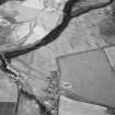
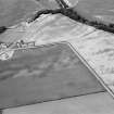
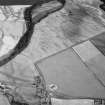
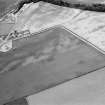
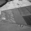
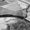
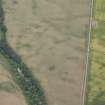
A review of the evidence now suggests that the two best defined lines are possibly a pit-defined cursus.

Information from H L Winton (RCAHMS)

Activities

Note (1983)

Inchbare 2 NO 607 657 to 609 658 NO66NW

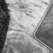
Cropmarks reveal at least four lines of pits running from WSW to ENE across the field to the NE of Inchbare. The two best-defined lines are set about 25m apart and are visible for a distance of about 200m. The third, whose alignment diverges slightly towards the ENE, lies between 6m and 16m to the S, and the fourth lies a further 20m to the S.

RCAHMS 1983.

Aerial Photographic Transcription (1 June 1992 - 4 June 1992)

An aerial transcription was produced from oblique aerial photographs. Information from Historic Environment Scotland (BM) 31 March 2017.

Archaeological Evaluation (22 July 2020)

A programme of archaeological investigative works was carried out for Stracathro Estates in support of proposed development at Inchbare, Edzell in Angus by Rathmell Archaeology. The works tested the archaeological potential of the area to inform on any appropriate mitigation of impact.

The works consisted of an intrusive sample by trenching, carried on the 22nd of June 2020. Eight trenches were excavated within the development area with no significant archaeological remains identified during the works. As a result, no further archaeological works are recommended.

Information from Sarah Krischer (Rathmell Archaeology) July 2020

OASIS ID: rathmell1-184696

References

MyCanmore Image Contributions


Contribute an Image

MyCanmore Text Contributions