Scheduled Maintenance
Please be advised that this website will undergo scheduled maintenance on the following dates: •
Tuesday 3rd December 11:00-15:00
During these times, some services may be temporarily unavailable. We apologise for any inconvenience this may cause.
Boysack
Pit Enclosure (Prehistoric), Souterrain(S) (Prehistoric), Unenclosed Settlement (Iron Age)
Site Name Boysack
Classification Pit Enclosure (Prehistoric), Souterrain(S) (Prehistoric), Unenclosed Settlement (Iron Age)
Canmore ID 35475
Site Number NO64NW 40
NGR NO 6192 4893
NGR Description Centred NO 6192 4893
Datum OSGB36 - NGR
Permalink http://canmore.org.uk/site/35475
- Council Angus
- Parish Inverkeilor
- Former Region Tayside
- Former District Angus
- Former County Angus
NO64NW 40 6192 4893.
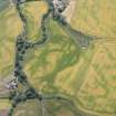
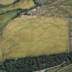
NO 619 489. Settlement (Site), Boysack: In the field SW of Boysack, air photographs show at least five circular crop-marks, each measuring about 17m in diameter, which probably represent the sites of timber houses forming an unenclosed settlement. Close by there is a sixth circular mark measuring about 10m in diameter which appears to form the SW corner of a narrow sub-rectangular palisaded enclosure defined by pits measuring about 50m in length NW-SE by 15m in breadth. An area of rig-and-furrow cultivation crosses the field N-S.
RCAHMS 1978
Oblique aerial photographs (RCAHMSAP 1995) reveal the cropmarks of two souterrains, approximately 40m NE of the rectangular enclosure. The souterrains both measure about 12m in diameter.
Information from RCAHMS (KJ) 12 April 1999.
Field Visit (March 1978)
Boysack NO 619 489 NO64NW
In the field SW of Boysack, air photographs show at least five circular cropmarks, each measuring about 17m in diameter, which probably represent the sites of timber houses forming an unenclosed settlement. Close by there is a sixth circular mark measuring about 10m in diameter, which appears to form the SW corner of a narrow rectangular palisaded enclosure measuring about 35m in length by 15m in breadth.
RCAHMS 1978, visited March 1978
Aerial Photographic Transcription (23 February 1992 - 6 March 1992)
An aerial transcription was produced from oblique aerial photographs. Information from Historic Environment Scotland (BM) 31 March 2017.


