
Corbie Knowe


Enclosure (Period Unassigned)(Possible)
Site Name Corbie Knowe
Classification Enclosure (Period Unassigned)(Possible)
Canmore ID 143864
Site Number NO64NE 75
NGR NO 6918 4891
Datum OSGB36 - NGR
Permalink http://canmore.org.uk/site/143864


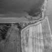
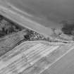
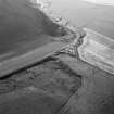
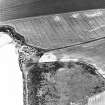
- Council Angus
- Parish Inverkeilor
- Former Region Tayside
- Former District Angus
- Former County Angus
Watching Brief (25 September 2018)
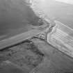
Alder Archaeology conducted a watching brief during the excavation of the footprint of a new beach hut, centred on NGR NO 69198 48870, at Corbie Knowe near Inverkeilor. Groundworks were carried out by a mechanical mini-digger with a toothless ditching bucket, which dug through natural beach sand and recent made ground. The work (site code JL03) was undertaken on 25th September 2018 in fine weather. No finds or features of archaeological interest were encountered.
Information from Alder Archaeology Ltd (C Fyles) 2018
OASIS ID: alderarc1-329609

