
Pricing Change
New pricing for orders of material from this site will come into place shortly. Charges for supply of digital images, digitisation on demand, prints and licensing will be altered.
Balcomie


Ring Ditch (Period Unassigned)
Site Name Balcomie
Classification Ring Ditch (Period Unassigned)
Canmore ID 35371
Site Number NO61SW 8
NGR NO 62738 10327
Datum OSGB36 - NGR
Permalink http://canmore.org.uk/site/35371


- Council Fife
- Parish Crail
- Former Region Fife
- Former District North East Fife
- Former County Fife
NO61SW 8 62738 10327
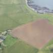
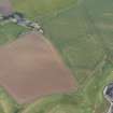
NO 627 103. Ring-ditch, Balcomie: visible on RCAHMS aerial photographs taken in 1978.
(Undated) information in NMRS.
Aerial reconnaissance has recorded a the cropmark of a ring-ditch about 450m NE of Balcomie Farm Cottages. It measures about 12m in diameter and there is a slight break in the circuit to the ENE. There are patches of rig in the same field and also a series of circular and curvilinear markings in grass about 500m to the SE but the archaeological significance of these is uncertain.
Transcription prepared by RCAHMS (MMB) 23 January 1996.
Information from RCAHMS (RHM), 13 August 1996.
Aerial Photographic Transcription (23 January 1996 - 13 February 1996)
An aerial transcription was produced from oblique aerial photographs. Information from Historic Environment Scotland (BM) 31 March 2017.

