
Burn Of Keenie


Building (Post Medieval), Field System (Post Medieval), Rig And Furrow (Medieval) - (Post Medieval), Sheepfold (19th Century)
Site Name Burn Of Keenie
Classification Building (Post Medieval), Field System (Post Medieval), Rig And Furrow (Medieval) - (Post Medieval), Sheepfold (19th Century)
Alternative Name(s) Skelly Farm; Skelly
Canmore ID 158336
Site Number NO57NW 30
NGR NO 512 772
NGR Description Centred NO 512 772
Datum OSGB36 - NGR
Permalink http://canmore.org.uk/site/158336


- Council Angus
- Parish Lochlee
- Former Region Tayside
- Former District Angus
- Former County Angus
NO57NW 30 centred 512 772
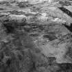
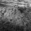
A single unroofed building, a sheepfold and a field-system is depicted on the 1st edition of the OS 6-inch map (Forfarshire 1865, sheet xiii). A field-system is shown on the current edition of the OS 1:10000 map (1976).
Information from RCAHMS (AKK) 30 June 1999.
(GRC/AAS NO57NW 22: name cited as Skelly and location as NO 5132 7726). Air photography (AAS/01/1/G2/3-4 and AAS/01/1/CT/14, 15 and 19, flown 13 February 2001) has recorded six irregular-shaped attached enclosures on a moderate NE-facing slope above Skelly Farm, and at an altitude of 260m OD. They contain rigs and that to the SE is overlain by a later wall around the plantation.
(GRC/AAS NO57NW 35: name cited as Skelly and location as NO 5109 7725). Air photography (AAS/01/1/G2/3, 4, 8 and AAS/01/1/CT/13-15, flown 13 February 2001) has recorded the remains of several irregular-shaped enclosures (containing rigs) and several buildings on a gentle NE-facing slope on the S side of Glen Esk, and at an altitude of 280m OD.
(Extent indicated on GIS plot).
NMRS, MS/712/102.
The following sites were recorded during winter aerial reconnaissance. Details of each site have been deposited in the NMRS.
NO 5132 7726 Six irregular-shaped attached enclosures containing rigs on NE-facing slope above Skelly Farm.
Sponsors: Aberdeenshire Council, Angus Council, RCAHMS
M Greig 2001f

