
Pricing Change
New pricing for orders of material from this site will come into place shortly. Charges for supply of digital images, digitisation on demand, prints and licensing will be altered.
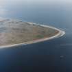
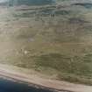
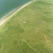
Buddon Ness, Old High Lighthouse And Keeper's House


Cottage (19th Century), Lighthouse (19th Century)
Site Name Buddon Ness, Old High Lighthouse And Keeper's House
Classification Cottage (19th Century), Lighthouse (19th Century)
Alternative Name(s) Barry Buddon; Barry Links; Budden Ness; Outer Tay Estuary; Firth Of Tay; North Sea
Canmore ID 34585
Site Number NO53SW 21
NGR NO 53904 30986
Datum OSGB36 - NGR
Permalink http://canmore.org.uk/site/34585


- Council Angus
- Parish Barry
- Former Region Tayside
- Former District Angus
- Former County Angus
NO53SW 21 53904 30986
See also:
NO53SW 55.00 54211 30841 Low Lighthouse
NO53SW 93 53883 31008 High Lighthouse
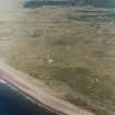
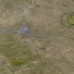
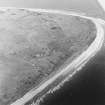
Buddon Ness
High Lighthouse
(Disused) [NAT]
OS 1:10,000 map, 1974.
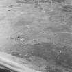
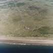
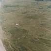
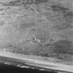
The two lighthouses on Buddon Ness were built in 1865-6 by engineers D and T Stevenson. The high lighthouse (NO53SW 93) is a tall circular tower and still in use, but the low lighthouse (NO53SW 55) is a similar but shorter building, which is now disused.
J R Hume 1977.
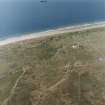
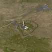
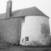
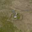
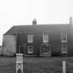
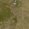
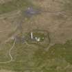
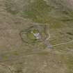
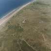
The original high lighthouse is shown on the 1st Edition of the OS 6-inch map (Forfarshire, 1855-65, sheet lv), at the N end of the lighouse keepers cottage (NO 53907 30992). It has been reduced to its lower courses and is now incorporated into the rest of the building. It has had a slated roof added at the same level as the adjacent cottages. Internally part of the spiral staircase survives, ending abruptly at the new roof level. The original stone flagged flooring is also in situ.
The keepers cottage (NO 53904 30986), is stone built, two storeys high with a slated roof. The lighthouse and cottage are dated to around 1820.
About 25m NE (NO 53930 30989) is another smaller cottage, stone built, single storey and slated with what may be an external toilet at the N end. This building is not shown on the 1st edition 6-inch map (ibid), but does appear with a smaller hut on the 1901 edition.
The old lighthouse is clearly depicted on the 1st edition OS 25-inch scale maps (Forfarshire, sheet lv), but by the 2nd edition 6-inch, Forfarshire, 1901, sheet lv) after the newer brick built whitewashed lighthouse of 1865 (NO53SW 93), had been constructed, only the curved N end of the lighthouse keepers cottage is evidence on the map of the original lighthouse.
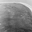
The old lighthouse, cottages and new lighthouse (NO53SW 93), are now surrounded by a barbed-wire fence and in use by the Army Cadet Training units (ACT) for their summer camps. There are four small concrete sentry boxes incorporated into the perimeter fence.
Visited by RCAHMS (DE, SW), 10 August 2005
NO53SW 21 53904 30986
NMRS REFERENCE
Architect: R. Stevenson, Engineer 1865-66.
Construction (1688)
Replaced by a wooden tower in 1753.
K Allardyce and E M Hood 1998
Field Visit (10 August 2005)
The original high lighthouse is shown on the 1st Edition of the OS 6-inch map (Forfarshire, 1855-65, sheet lv), at the N end of the lighouse keepers cottage (NO 53907 30992). It has been reduced to its lower courses and is now incorporated into the rest of the building. It has had a slated roof added at the same level as the adjacent cottages. Internally part of the spiral staircase survives, ending abruptly at the new roof level. The original stone flagged flooring is also in situ.
The keepers cottage (NO 53904 30986), is stone built, two storeys high with a slated roof. The lighthouse and cottage are dated to around 1820.
About 25m NE (NO 53930 30989) is another smaller cottage, stone built, single storey and slated with what may be an external toilet at the N end. This building is not shown on the 1st edition 6-inch map (ibid), but does appear with a smaller hut on the 1901 edition.
The old lighthouse is clearly depicted on the 1st edition OS 25-inch scale maps (Forfarshire, sheet lv), but by the 2nd edition 6-inch, Forfarshire, 1901, sheet lv) after the newer brick built whitewashed lighthouse of 1865 (NO53SW 93), had been constructed, only the curved N end of the lighthouse keepers cottage is evidence on the map of the original lighthouse.
The old lighthouse, cottages and new lighthouse (NO53SW 93), are now surrounded by a barbed-wire fence and in use by the Army Cadet Training units (ACT) for their summer camps. There are four small concrete sentry boxes incorporated into the perimeter fence.
Visited by RCAHMS (DE, SW), 10 August 2005

