
Pricing Change
New pricing for orders of material from this site will come into place shortly. Charges for supply of digital images, digitisation on demand, prints and licensing will be altered.
Craigmill


Barrow(S) (Prehistoric)
Site Name Craigmill
Classification Barrow(S) (Prehistoric)
Canmore ID 34494
Site Number NO53NE 15
NGR NO 5798 3580
Datum OSGB36 - NGR
Permalink http://canmore.org.uk/site/34494


- Council Angus
- Parish Panbride
- Former Region Tayside
- Former District Angus
- Former County Angus
NO53NE 15 5798 3580
See also NO53NE 29 and NO53NE 78.
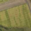
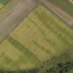
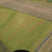
Oblique aerial photographs (RCAHMSAP 1983, 1995) show the cropmarks of at least five round barrows, situated in a field, approximately 150m SE of Craigmill farm. They measure between 8-12m in diameter, with centrally placed pits which may represent burials.
Information from RCAHMS (KJ) 28 April 1999.

