
Pricing Change
New pricing for orders of material from this site will come into place shortly. Charges for supply of digital images, digitisation on demand, prints and licensing will be altered.
Battledykes


Enclosure (Prehistoric)
Site Name Battledykes
Classification Enclosure (Prehistoric)
Canmore ID 33669
Site Number NO45NE 14
NGR NO 45873 55288
Datum OSGB36 - NGR
Permalink http://canmore.org.uk/site/33669


- Council Angus
- Parish Oathlaw
- Former Region Tayside
- Former District Angus
- Former County Angus
NO45NE 14 NO 45873 55288
(NO 4587 5530) Tumulus (R) (Site of) (NAT)
OS 6" map, Forfarshire and Angus, 2nd ed., (1927)
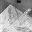
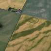
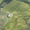
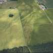
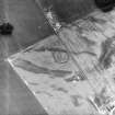
The OSA (1791-9), Stuart (1856) and Jamieson (Nichols 1780-90) all mention the existence of two tumuli within a Roman camp (NO45NE 12) the other being NO45NE 13. Jamieson describes this as triangular, entirely composed of gravel brought from a distance, measuring 84 paces around the base. It lies within the camp, facing the W gate, and about 100 paces from it. Cropmarks visible on J K St Joseph air photographs DE 27 1686 GO 27 and RAF air photographs 541/A/477 3011-2 which St Joseph alleges are of a "native site" at this spot.
Name Book 1862; J Stuart 1856; J Nichols (ed.) 1780-90.
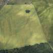
Dr St Joseph and RAF air photographs show two concentric ringed soil marks, the outer one being about 50m in diameter, on the site of the alleged tumulus. On the ground nothing was noted as the field was under high crop at the time of visit. The site is on a knoll, and it appears that the outer "ring" falls around the base of this. It may have been a ditch or simply a natural water-logged area around the base of the mound.
Visited by OS (JLD) 15 August 1958.
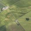
This site falls on regularly cultivated land and nothing was visible on the ground.
Visited by OS (TRG) 6 January 1977.
Note (1983)
Battledykes NO 458 552 NO45NE 14
Cropmarks 230m SSE of Battledykes farmhouse reveal an oval enclosure, measuring about 45m by 35m within a ditch 4.5m broad. It lies immediately S of what is supposed to have been the site of an artificial gravel mound.
RCAHMS 1983.
(Name Book, Forfar, No. 75, p. 14; Crawford 1949, 95-6).

