
Following the launch of trove.scot in February 2025 we are now planning the retiral of some of our webservices. Canmore will be switched off on 24th June 2025. Information about the closure can be found on the HES website: Retiral of HES web services | Historic Environment Scotland
Douglas Wood, Type 27 Pillbox


Pillbox (20th Century)
Site Name Douglas Wood, Type 27 Pillbox
Classification Pillbox (20th Century)
Alternative Name(s) The Brackens
Canmore ID 148618
Site Number NO44SE 46.04
NGR NO 48337 41166
Datum OSGB36 - NGR
Permalink http://canmore.org.uk/site/148618


- Council Angus
- Parish Monikie
- Former Region Tayside
- Former District Angus
- Former County Angus
NO44SE 46.04 48337 41166
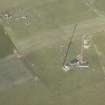
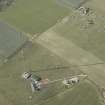
A type 27 pillbox is situated at the NW corner of the enclosure containing the the four mast bases and a transmitter/receiver block.
The pillbox is visible on vertical air photographs taken in 1947 (CPE/Scot/UK 304, 3078-3080, flown 26 September 1947).
Information from RCAHMS (DE), October 2005

