
Pricing Change
New pricing for orders of material from this site will come into place shortly. Charges for supply of digital images, digitisation on demand, prints and licensing will be altered.
Upcoming Maintenance
Please be advised that this website will undergo scheduled maintenance on the following dates:
Thursday, 9 January: 11:00 AM - 3:00 PM
Thursday, 23 January: 11:00 AM - 3:00 PM
Thursday, 30 January: 11:00 AM - 3:00 PM
During these times, some functionality such as image purchasing may be temporarily unavailable. We apologise for any inconvenience this may cause.
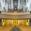
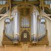
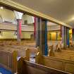
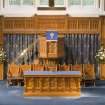
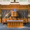
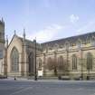
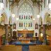
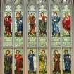
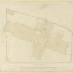
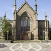
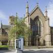
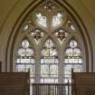
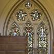
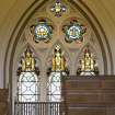
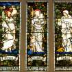
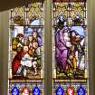
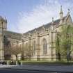
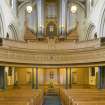
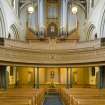
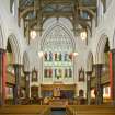
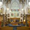
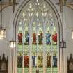
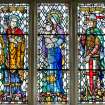
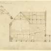
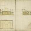
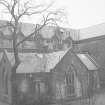
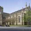
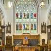
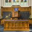
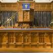
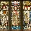
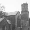
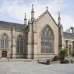
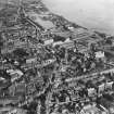
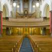
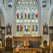
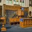
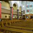
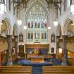
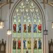
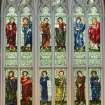
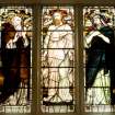
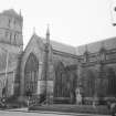
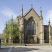
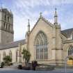
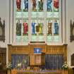
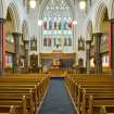
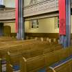
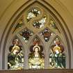
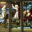
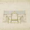
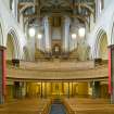
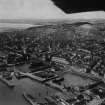
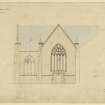
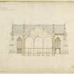
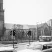
Dundee, Nethergate, City Churches, St Mary's Parish Church And War Memorial


Church (19th Century) (1844), War Memorial(S) (20th Century) (1921)
Site Name Dundee, Nethergate, City Churches, St Mary's Parish Church And War Memorial
Classification Church (19th Century) (1844), War Memorial(S) (20th Century) (1921)
Alternative Name(s) St Mary's East; Dundee Parish Church; St Mary's Hall; East Church; Black Watch Memorial
Canmore ID 185632
Site Number NO43SW 359
NGR NO 40186 30136
Datum OSGB36 - NGR
Permalink http://canmore.org.uk/site/185632


- Council Dundee, City Of
- Parish Dundee (Dundee, City Of)
- Former Region Tayside
- Former District City Of Dundee
- Former County Angus
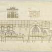
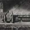
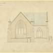
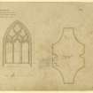
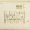
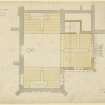
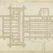
Gothic revival church by William Burn, 1841. Built after a fire destroyed the orginal transepts and choir in a huge fire. The decision was made to build from new, rather than reinstate using the remains of the earlier church.
RCAHMS (CAJS) 2012.
NO43SW 359 40186 30136
For architectural fragments (probably from this church) held in Balgay Park (centred NO 3798 3077), see NO33SE 540.04.
NMRS REFERENCE:
Dundee, Nethergate, City Churches, St Mary's or East Church or Dundee Parish Church
1843-4
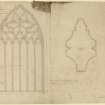
Architect: Wm Burn 1843-4 rebuilt on site after fire of 1841
Wm Alexander 1896-7 - Hall
Dundee, Nethergate, City Churches.
Architect: Samuel Bell 1788 St Clement's.
William Burn 1828 Restoration.
William Burn 1841 Restoration after fire - OId St Paul's & St David's
St Mary's Church
NMRS/Simpson & Brown photographs
Box 8 album no 117
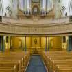
1989 exterior and many interior views.
Dundee, St Mary's Hall
ARCHITECT: William Alexander 1896-7
Dundee, Nethergate, City Churches, St Mary's Church.
EXTERNAL REFERENCE:
SCOTTISH RECORD OFFICE
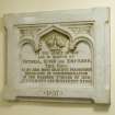
Repair of the Old Church.
Receipt for James Fotheringham Scrymsoure's interim payments towards his proportion of the expense.
1826 GD 121/3/84
Observation (1842)
Several medieval graveslabs were also found during the reconstruction of the East Kirk in 1842.
Perry, 2005
Grave slab bearing representation of a ship with a cross for a mast. A bear ascending the rigging on the right side of the cross. This was found during the excavation for foundation of the new East Church in 1842.
Stevenson and Torrie, 1988
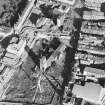
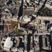
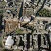
Excavation (1992 - 1993)
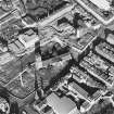
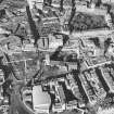
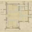
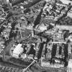
Excavation and a watching brief in 1992-3 by SUAT Ltd during environmental improvements in the area of the City Churches revealed a ditch, which had been re-cut, extending southwards from the church. It was sealed beneath a medieval graveyard from which remains of 130 skeletons were recovered, along with a large quantity of disarticulated human bone. A stone box drain for the 19th century St Mary's parish church was cut into the graveyard.
The 1992-1993 excavation trenches, A to H, were located to the S of the City Churches, with one exception which was situated in front of the W door. Excavation was confined to only those areas were wall foundations, drainage pipe trenches or other groundworks disturbed the graveyard soil. As well as the trenches dug a watching brief was maintained on other groundworks in the precinct which led to a further trench, H, in a area of interest outside the W door to the tower. [1]
The main objective of the excavation was to record and remove the human remains that were threatened by deep foundation trenches and new drainage tracks. A further objective was to resolve the question as to whether the burials were related to the massacre in 1651 or were earlier medieval burials. It was hoped that evidence of structures would also be found, as Crawfurd's 18th century maps showed buildings along the Nethergate, as well as wider transepts on the church. [2]
The excavation produced firm evidence for a graveyard around the south and west sides of the church building, in areas once thought to have been devoid of burials. A total of 130 skeletons were excavated along with a large quantity of disarticulated human bone. Intercutting burials in each of the examined areas support the conclusion that this graveyard was used over a considerable number of years, and that there was no sign of a mass grave from General Monck's massacre in 1651. All ages were represented, as were both sexes. Areas of greater and lesser density of burials were also identified, although it is difficult to tell if this represents the use of individual layers. Preservation, in general, was poor and coffins were inferred with corroded nails found with some of the burials. Generally the coffins seem to be late in the burial sequence, perhaps indicating a change in burial practice during the use of the cemetery.
Dating the cemetery accurately is difficult, but it is apparently disused by the time that a stone culvert is inserted. This culvert was certainly present by 1841, as it was used for drainage by the architects of the 19th century rebuilding of the chancel and transepts. An earlier date for this drain is possible, as a similar one was encountered during construction south of the late 18th century nave.
The presence of burials cut by the steeple also indicates that at least one part of the cemetery had come in and gone out of use by the end of the 15th century. This agrees with the pottery recovered from sealed graves, which is 12th to 15th century in date.
The earliest date for burial is also in doubt. The only feature predating the graveyard has no dating evidence in it, and the historical evidence is sparse. This early ditch, with its possible gravel bank, may have formed part of the early town defences, and would almost certainly had predated the founding of the building that currently crosses its projected line. If projected southwards, it would have given shelter to Spalding's Wynd, which was formerly known as Abbot's Wynd. As such, its use as a town defence prior to Earl David's founding of a church in the late 12th century is not unreasonable. Further work in the Nethergate area will be needed to provide a more substantial answer.
As for the survival of archaeological deposits around the remainder of the church precinct, the results of watching briefs were poor. The pipe trench running down the west side of the church produced nothing but natural gravel and brick basements from the former South Lindsey St.
Information from SUAT
Trial Trench (September 1996)
NO 4005 3005 In September 1996 SUAT excavated eight trial trenches in and around the 1960s Overgate Centre on the SW side of the City Churches, in advance of redevelopment. The trenches found relatively little evidence of medieval occupation which seemed to confirm that the construction of the present centre had mostly destroyed such remains. Some disturbed and truncated medieval deposits were, however, identified in two trenches and a few sherds of medieval pottery were recovered. Isolated pockets of archaeology may have survived within the complex, and further work in the form of a watching brief is due to take place when redevelopment begins.
Sponsor: TBI plc.
R Cachart 1996
Trial trenching by SUAT Ltd. In 1996 revealed that the construction of the centre in the 1960s had not completely destroyed all traces of medieval occupation; disturbed and truncated medieval deposits were found in two trenches, along with some medieval pottery. [1]
Eight trial trenches were hand dug around the Overgate Centre as part of an archaeological evaluation prior to development. The excavations were undertaken to identify and evaluate all relevant archaeological deposits or features, particularly those thought to relate to the main thoroughfares of Nethergate and Over gate, an early city boundary ditch, burials around the north side of St Mary's Church and the Franciscan Nunnery.
The trial trenches revealed the following:
Trench A Shallow, modern deposits overlay natural sand.
Trench B Modern services cut an unbottomed deep fill of a probable backfilled basement.
Trench C Deep disturbance was caused by modern services with intercutting fills.
Trench D A shallow wall feature represented the remains of a demolished 19th-century urinal infilled with rubble from which two fragments of human bone were recovered.
Trench E Disturbance by modern services had cut through a wall and infilled basement. A disturbed medieval deposit lay the natural sand.
Trench F A very deep upfilling of modern make-up that was not bottomed.
Trench G A former road surface below which relatively modern services and a probable backfilled basement or well had disturbed medieval make-up of an early road.
Trench H - The modern services inserted alongside the foundation remains of a frontage building had disturbed underlying deposits.
The trial work produced no conclusive evidence relating to the four main objectives. Evidence of medieval occupation in the form of disturbed deposits containing residual medieval pottery was however found, and could indicate that pockets of medieval archaeology may well survive intact in other areas of the proposed development. Two small residual fragments of human bone found within an infilling on the north side of the City Churches could suggest that burials took place on this side of the church.
Information from SUAT,
Archaeological Assessment at the Overgate Centre, Dundee.
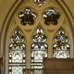
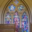
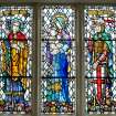
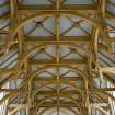
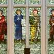
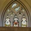
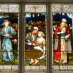
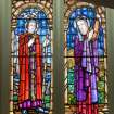
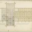
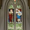
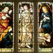
Photographic Survey (10 February 2012)
Photographed by the Listed Building Area Survey, Dundee upgrade programme.
RCAHMS (CAJS)

