
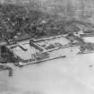
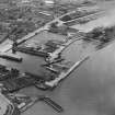
Dundee, Dock Street, King William Iv Dock, Entrance Lock, Swing Bridge


Swing Bridge (Period Unassigned)
Site Name Dundee, Dock Street, King William Iv Dock, Entrance Lock, Swing Bridge
Classification Swing Bridge (Period Unassigned)
Alternative Name(s) Port Of Dundee; Dundee Harbour; River Tay; Firth Of Tay
Canmore ID 280494
Site Number NO43SW 1002.02
NGR NO 40637 30125
Datum OSGB36 - NGR
Permalink http://canmore.org.uk/site/280494


- Council Dundee, City Of
- Parish Dundee (Dundee, City Of)
- Former Region Tayside
- Former District City Of Dundee
- Former County Angus
NO43SW 1002.02 40637 30125
The location assigned to this record remains unverified from current map evidence, within an area of car parks and urban redevelopment. Is noted and depicted in detail by GIS historic mapping (epoch 2).
Information from RCAHMS (RJCM), 18 April 2006.

