
Pricing Change
New pricing for orders of material from this site will come into place shortly. Charges for supply of digital images, digitisation on demand, prints and licensing will be altered.
Easter Kinnear


Barrow (Prehistoric), Enclosure(S) (Period Unassigned)(Possible), Enclosure(S) (Period Unassigned), Ring Ditch(S) (Period Unassigned), Unenclosed Settlement (Period Unassigned), Unidentified Pottery (Neolithic)
Site Name Easter Kinnear
Classification Barrow (Prehistoric), Enclosure(S) (Period Unassigned)(Possible), Enclosure(S) (Period Unassigned), Ring Ditch(S) (Period Unassigned), Unenclosed Settlement (Period Unassigned), Unidentified Pottery (Neolithic)
Canmore ID 33257
Site Number NO42SW 27
NGR NO 40519 23382
NGR Description Centred on NO 40519 23382
Datum OSGB36 - NGR
Permalink http://canmore.org.uk/site/33257


- Council Fife
- Parish Kilmany
- Former Region Fife
- Former District North East Fife
- Former County Fife
NO42SW 27 Centred on NO 40519 23382
See also NO42SW 26.
The Scottish Field School of Archaeology excavation programme moved from North Straiton (NO42SW 37) to a new group of cropmark sites on a ridge of sand and gravel a few hundred metres to the east on the farm of East Kinnear. The field operations were directed by Dr Steve Driscoll, while Dr Watkins acted as overall director of the Field School.
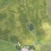
The crop-mark selected appeared as a dark, rather ill-defined blur about 10 metres across, around whose edges sharply defined linear earthworks could be seen for about two thirds only of the central blur's perimeter. As in previous seasons a larger area was opened for excavation than was necessary to enclose the crop-mark, in part for fear of having the crop-mark inaccurately transcribed from the aerial photographs, and in part in order to have some view of what features existed beyond the immediate area of the crop-mark. The archaeological features responsible for the crop-mark were identified in the W side of the 400 square metre excavation area. Apart from a few postholes in the NW corner of the area there were very few other features. In the NE corner of the excavation area part of a rectilinear foundation for a timber building was located but could not be followed up for lack of resources. The main crop-mark site resolved itself into two sets of elements, the central blur being found to be a deep, stone-revetted, unfloored scoop in the sand below the ploughsoil, and the peripheral linear earthworks being found to be a series of trenches which had contained timber structures. The dating evidence for the structures was ambiguous, and will be resolved only by radio-carbon dating; the features were below a ploughed soil which contained medieval pottery of about the thirteenth century, and the finds from the features ranged from a single early neolithic sherd and a piece of saddle quern to pieces of rotary quern made of mica schist (familiar from souterrain sites and later Iron Age settlements) and a whetstone whose closest parallels are found in sites of eighth or ninth century date. The lack of pottery may also suggest a first millenium date, and the best estimate for the present is that the site post-dates the early centuries of the first millenium A.D. and lies in the middle or latter half of that millennium.
The subterranean scoop was roughly egg-shaped in plan and more than one metre deep. The sides were revetted with large, water-worn boulders. The N end of the chamber had a straight wall, whose two ends were marked by rather tall stones set upright. No trace of the above-ground superstructure which went with the scoop was found, but almost all the available space around the scoop was disturbed by the secondary structures represented by the linear ditches. An alternative solution might be that the superstructure was designed to stand immediately on top of the stone retaining wall of the scoop. Before the succeeding timber constructions were built a secondary use was made of part of the somewhat silted hollow left by the subterranean chamber: in its SW quadrant a furnace had burnt fiercely and often in a small circular scoop, and the hollow had been protected with a particularly large boulder set on edge. The remains of the scoop were finally filled in with a great amount of mixed sand and soil, and at the same time the top of the revetting wall was slighted.
The secondary sequence of timber buildings is focussed closely on the same spot. The several linear trenches seem to have contained light timber constructions, in one place at least found burnt and resembling the vertical sticks of wattle. There appear to have been at least four successive builds, some of the trenches interfering with the side walls of the old, buried scoop. The remains of the buildings are heavily interwoven, and the scope for paper reconstruction is likely to be rather limited. The general outlines of the buildings, however, can be seen to have been sub-rectangular and almost square, the sides being slightly bowed and the angles being notably rounded.
The fieldwork was supported by Historic Buildings and Monuments, Scottish Office Environmental Programme, the Russell Trust and the British Academy.
S Driscoll 1989a; S Driscoll and T Watkins 1989.
Four radiocarbon dates were reported from samples taken in 1989. Three of these relate to the burnt remains of a rectangular wooden building which postdated the cellar-like, subterranean structure. The fourth is a single date taken from a hearth situated in the subterranean structure after its abandonment and before wooden buildings once again enclosed the area. The pooled mean of the three dates from the burnt structure indicate a (calibrated) date in the late sixth or early seventh centuries A.D. The fourth date is inexplicably more than two thousand years earlier, and lacks support from artefactual finds.
T Watkins and P Freeman 1991.
Aerial Photographic Transcription (10 July 1990 - 18 July 1990)
An aerial transcription was produced from oblique aerial photographs. Information from Historic Environment Scotland (BM) 31 March 2017.

