
Pricing Change
New pricing for orders of material from this site will come into place shortly. Charges for supply of digital images, digitisation on demand, prints and licensing will be altered.
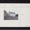
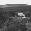
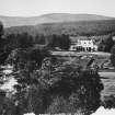
Birkhall


Country House (18th Century)
Site Name Birkhall
Classification Country House (18th Century)
Alternative Name(s) Balmoral Estates; Birkhall Estate
Canmore ID 32479
Site Number NO39SW 1
NGR NO 34901 93600
Datum OSGB36 - NGR
Permalink http://canmore.org.uk/site/32479


- Council Aberdeenshire
- Parish Glenmuick, Tullich And Glengairn
- Former Region Grampian
- Former District Kincardine And Deeside
- Former County Aberdeenshire
NO39SW 1.00 34901 93600
(NO 3488 9360) The house of Birkhall, built by the Gordons of Abergeldie, has a stone over its front door inscribed R.G. M.G. 1715. It was formerly called Stiren and is marked as "Steirn" on Gordon of Straloch's map of 1654. It is a plain three-storeyed house which has been greatly altered since 1715, and is now owned by the Royal Family.
A Jervise 1875-9; A I McConnachie 1898; W D Simpson 1949.
Birkhall, formerly Stiren, as described above.
Visited by OS (A A) 3 November 1967.
Listed.
Scottish Castle Survey 1988; N Bogdan and I B D Bryce 1991.
OWNER: was HRH The Queen Mother, since inherited by the Prince of Wales.
Birkhall Farm, precise location uncertain. Possibly NO 3483 9384?
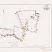
NMRS PLANS: F.A.M. MacDonald Collection - 1888 Estate plan.
All 2001 RCAHMS survey material is held on restricted access.

