
Following the launch of trove.scot in February 2025 we are now planning the retiral of some of our webservices. Canmore will be switched off on 24th June 2025. Information about the closure can be found on the HES website: Retiral of HES web services | Historic Environment Scotland
Carpow


Linear Feature(S) (Period Unassigned)
Site Name Carpow
Classification Linear Feature(S) (Period Unassigned)
Canmore ID 71840
Site Number NO21NW 88
NGR NO 20463 17761
Datum OSGB36 - NGR
Permalink http://canmore.org.uk/site/71840


- Council Perth And Kinross
- Parish Abernethy (Perth And Kinross)
- Former Region Tayside
- Former District Perth And Kinross
- Former County Perthshire
NO21NW 88 20463 17761
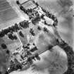
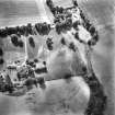
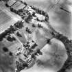
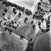
Aerial photography (RCAHMSAP 1989) has recorded the cropmarks of several linear features immediately W of the Roman legionary fortress NO21NW 24.00. The slighter features are probably the furrows of broad rig-and-furrow cultivation, but others clearly represent more substantial ditches.
While the date and purpose of these ditches are unknown, it is likely that they are elements of the defences of annexes or enclosures associated with the Roman occupation of the site.
Information from RCAHMS (JRS), 4 February 1997.
Aerial Photographic Transcription (31 December 1993)
An aerial transcription was produced from oblique aerial photographs. Information from Historic Environment Scotland (BM) 31 March 2017.

