
Carpow


Enclosure (Roman), Pit(S) (Roman)
Site Name Carpow
Classification Enclosure (Roman), Pit(S) (Roman)
Canmore ID 30119
Site Number NO21NW 59
NGR NO 20715 17696
Datum OSGB36 - NGR
Permalink http://canmore.org.uk/site/30119


- Council Perth And Kinross
- Parish Abernethy (Perth And Kinross)
- Former Region Tayside
- Former District Perth And Kinross
- Former County Perthshire
NO21NW 59 207 176.
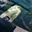
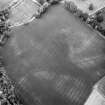
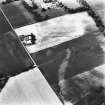
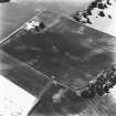
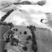
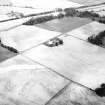
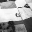
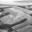
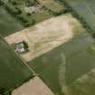
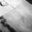
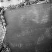
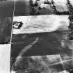
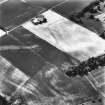
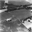
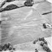
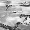
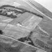
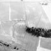
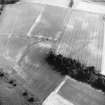
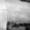
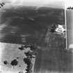
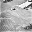
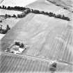
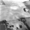
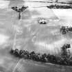
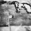
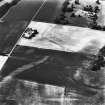
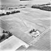
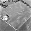
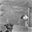
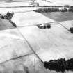
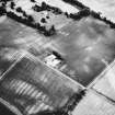
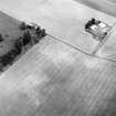
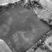
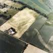
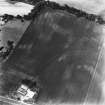
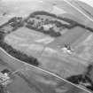
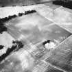
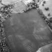
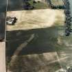
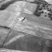
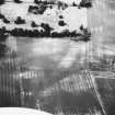
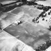
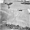
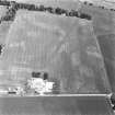
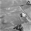
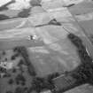
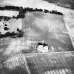
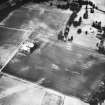
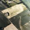
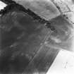
Overlying the camp (NO21NW 58) and outside the fort (NO21NW 24) to the S is to the S is the cropmark of a polygonal enclosure, the ditch of which has been traced for 2,425' in three straight sectors, meeting at obtuse angles. In the central sector are two gates, each with a titulum. A trial trench showed the ditch to be V-shaped, 11' wide and 4 1/2' deep. It evidently formed the landward defences of an area of 70 acres, bounded on the N by the steep slope down to the River Tay.
J K St Joseph 1969; 1973.
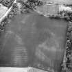
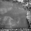
Nothing is visible of the large polygonal Roman enclosure that has been recorded by aerial photography (RCAHMSAP 1976, 1977, 1981, 1982, 1983, 1986, 1990, 1991, 1992, 1994 and 1996) around the fortress (NO21NW 24.00) at Carpow. Aerial photography has also recorded a large number of pits both inside and outside the enclosure.
Information from RCAHMS (JRS), 4 February 1997.
Aerial Photographic Transcription (31 December 1993)
An aerial transcription was produced from oblique aerial photographs. Information from Historic Environment Scotland (BM) 31 March 2017.
Archaeological Evaluation (14 March 2011 - 29 April 2011)
NO 207 177 (centred on) An evaluation was undertaken in advance of development at Mains of Carpow, Newburgh. The steading of Mains of Carpow is surrounded by a SAM (2275) relating to the Roman legionary fortress of Carpow, but is itself not scheduled. The work took place in two phases, 14–15 March 2011 and 28–29 April 2011. A total of 8% of the 4600m² area was evaluated with nine trenches varying in length from
16–34m. An extra area measuring 6 x 10.5m (Trench 10) was evaluated to further assess what mitigation measures might be required for a new build. Significant finds were major ditch features and a possible beam slot, all of which are believed to relate to the Roman occupation.
A further evaluation, 12–13 September 2013, consisted of the machine excavation of six trial pits, with the subsequent monitoring of the excavation for a water pipeline trench on 30 September 2013. The laying of the pipeline required scheduled monument consent as it was located on the site of Carpow Roman fort. The pipeline was laid within the ploughsoil to
avoid disturbing underlying deposits.
The pipeline trench extended from the wellhead, located at NO 2069 1793, in a SE direction, beside a field boundary fence line to NO 20816 17727 and then NE along a fence line in a NW direction to NO 20886 17764 at the NW corner of Carpow Steading, a total of 360m. Five test pits, evenly spaced, were excavated along the NW–SE aligned fence line and one along the much shorter NE–SW fence line. Three of the test pits measured 3 x 1m and three measured 1 x 1m.
In 1968 a N–S aligned trial trench, 62.5m in length, was excavated alongside the N end of the field boundary fence and investigated the E side of the principia or headquarters building. The trench crossed the principia and allowed the outer walls and interior of the building to be examined. It also intercepted a N–S aligned modern field drain. The modern field drain was found again during this investigation. It was noted in 1968 that the field drain had removed most of the archaeological deposits along its course.
The trial pits established that the ploughsoil had a depth of 0.30–0.35m. As in a trial trench of 1968 a modern field drain with a fill of gravel and whin fragments was found running alongside the NW–SE fence line. No other significant archaeological deposits or features were recorded. The
watching brief found further evidence of the whin fragments within the field drain and some small field boulders, two of which had mortar attached and may have come from the principia building, but no significant archaeological features were revealed.
Archive: RCAHMS (intended)
Funder: Mr F Edgley
Ray Cachart – Alder Archaeology Ltd
(Source: DES)

