
Pricing Change
New pricing for orders of material from this site will come into place shortly. Charges for supply of digital images, digitisation on demand, prints and licensing will be altered.
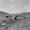
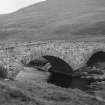
Glen Clunie, Clunie Water, Fraser's Bridge


Road Bridge (Period Unassigned)
Site Name Glen Clunie, Clunie Water, Fraser's Bridge
Classification Road Bridge (Period Unassigned)
Canmore ID 29711
Site Number NO18NW 2
NGR NO 14778 86466
Datum OSGB36 - NGR
Permalink http://canmore.org.uk/site/29711


- Council Aberdeenshire
- Parish Crathie And Braemar
- Former Region Grampian
- Former District Kincardine And Deeside
- Former County Aberdeenshire
NO18NW 2 14778 86466
This bridge, which carries the military road over the Clunie Water, measures 15' 4" between its parapets and is 100 ft long. It has two segmental arches and a parapet measuring some 2' 10" in height. Structure details are obscured by heavy pointing, but the arches and central pier are probably original. Due to affinities with Invercauld Old Bridge, a date of c.1752 is suggested for this bridge.
A Graham 1966.
(Location cited as NO 147 864 and name as Bridge over Clunie Water, Braemar). 18th century. A graceful 2-span rubble structure, with flattened segmental arches of unequal size and a triangular cutwater.
J R Hume 1977.

