
Cambusmichael


Enclosed Settlement (Prehistoric), Unenclosed Settlement (Prehistoric)(Possible)
Site Name Cambusmichael
Classification Enclosed Settlement (Prehistoric), Unenclosed Settlement (Prehistoric)(Possible)
Canmore ID 28669
Site Number NO13SW 42
NGR NO 1158 3229
Datum OSGB36 - NGR
Permalink http://canmore.org.uk/site/28669


- Council Perth And Kinross
- Parish St Martins
- Former Region Tayside
- Former District Perth And Kinross
- Former County Perthshire
Aerial Photographic Transcription (8 December 1989)
An aerial transcription was produced from oblique aerial photographs. Information from Historic Environment Scotland (BM) 31 March 2017.
Aerial Photographic Interpretation (10 December 1992)
NO13SW 42 1158 3229.
See also NO13SW 46.
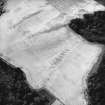
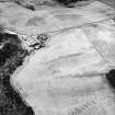
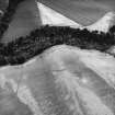
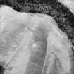
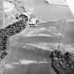
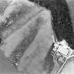
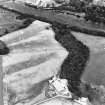
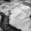
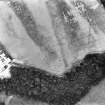
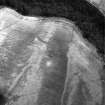
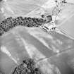
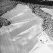
The cropmark of an oval enclosure (measuring about 30m by 27m) lies on the summit of a low ridge about 80m NW of Cambusmichael farmsteading. Crescentic markings within the interior indicate the position of a central round-house, while another crescent (immediately to the E at NO 1156 3227) reveals the position of a second (unenclosed) example. In the course of the survey of SE Perth, this site was classified as an enclosed crescent; in the majority of such cases, the enclosing perimeter appears to be a palisade trench, but here the cropmark suggests a wider feature, possibly a narrow ditch.
Information from RCAHMS (JRS) 10 December 1992.

