
Pricing Change
New pricing for orders of material from this site will come into place shortly. Charges for supply of digital images, digitisation on demand, prints and licensing will be altered.
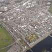
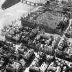
Perth, Canal Street, Greyfriars Burial Ground


Burial Ground (Post Medieval), Sundial (Post Medieval)
Site Name Perth, Canal Street, Greyfriars Burial Ground
Classification Burial Ground (Post Medieval), Sundial (Post Medieval)
Canmore ID 28370
Site Number NO12SW 204
NGR NO 11996 23263
NGR Description Centred on NO 11996 23263
Datum OSGB36 - NGR
Permalink http://canmore.org.uk/site/28370


- Council Perth And Kinross
- Parish Perth
- Former Region Tayside
- Former District Perth And Kinross
- Former County Perthshire
NO12SW 204 11996 23263
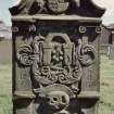
Memorials have various dates from 1580.
SDD 1960- (1976).
NO 119 232 In August 1997, SUAT hand-excavated two test-pits against the E wall of Greyfriars burial ground in advance of proposals to dismantle and rebuild much of the wall. The burial ground represents the site of the monastery and grounds of the Observant Order of Greyfriars, or Franciscans, or Friars Minor, in Perth, first mentioned in records in 1496.
In one pit what were considered to be the original Greyfriars wall foundations were located, and from these the probable contemporary ground level can be extrapolated. A succession of wall foundations revealed a history of wall replacement and repair with subsequent raising of the ground levels. Dating evidence in the form of medieval pottery associated with a probable lower garden soil against the Greyfriars original wall was also retrieved.
In the other pit, the lack of a succession of wall foundations confirmed that this area was within the 1795 graveyard extension and outwith the original ground of the monastery. The remains of the 1795 wall foundations lie directly below the present standing wall. Again it is possible to work out the probable ground level at the time of the extension. This pit also revealed a succession of infill/levelling layers probably dating from the infilling of a burn which ran parallel to the burial ground S wall prior to the 1795 extension.
The pits also revealed that burials extend from 1m down to c 1.8m, and lie hard up against the wall, which has no doubt contributed substantially to the instability of the present E wall. Depths of burials may vary a great deal from one lair to the next, and the tops of grave cuts appeared as high as 0.4m down.
Sponsor: Perth and Kinross Council.
R Cachart 1997
EXTERNAL REFERENCE
SRO
Perth. Greyfriars Churchyard. Tablet commemorated John Mylne who rebuilt the ancient bridge over the R.Tay. The tablet was erected by Robert Mylne in 1784. A letter from RW Mylne to Lord Prov. at Perth concerns the condition of the grave.
1848 GD 1/51/107
The sundial was removed from Springland, Perth, and placed in the NW corner of the burial ground in 1929 (MS 5741/6/32).

