
Pricing Change
New pricing for orders of material from this site will come into place shortly. Charges for supply of digital images, digitisation on demand, prints and licensing will be altered.
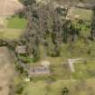
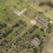
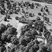
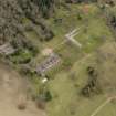
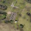
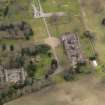
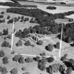
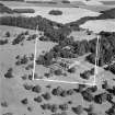
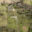
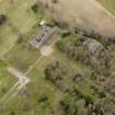
Scone Palace, Boot Hill, Mote Church Remains And Mausoleum


Architectural Fragment(S) (Period Unassigned), Church (17th Century), Mausoleum (17th Century)
Site Name Scone Palace, Boot Hill, Mote Church Remains And Mausoleum
Classification Architectural Fragment(S) (Period Unassigned), Church (17th Century), Mausoleum (17th Century)
Alternative Name(s) Moot Hill; Mortuary Chapel; Stormont Mausoleum
Canmore ID 28177
Site Number NO12NW 9.13
NGR NO 11418 26636
Datum OSGB36 - NGR
Permalink http://canmore.org.uk/site/28177


- Council Perth And Kinross
- Parish Scone
- Former Region Tayside
- Former District Perth And Kinross
- Former County Perthshire
NO12NW 9.13 11418 26636
Built in 1624. Replaced by a new church (NO12NW 9.17) in 1784. Remains are said to be incorporated in a mortuary chapel, remodelled by Atkinson in 1807.
OSA 1796; R Pococke 1887; A S Martin 1905.
The Stormont Mausoleum which stands on the summit of the Boot (or Moot) Hill (NO12NW 9.02) is said to be the aisle of the old parish church, which is believed to have been built about 1624, and was remodelled in 1807. The remainder of the church was demolished is about 1784, on the completion of the new parish church (NO12NW 9.17) which is said to have stood within the village of Old Scone (NO12NW 9.08), at a site now marked by a solitary table-tomb (NO 1170 2678). This church was itself demolished about 1804, its material being in part reused in the parish church at New Scone (NO12NW 59).
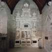
Within the Mausoleum, there is a fine baroque memorial to David, 1st Viscount Scone (died 1631) and a dormer pediment, which probably came from the 17th-century palace.
Visited by RCAHMS (IMS) March 1990.
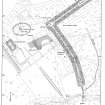
Measured Survey (5 September 1989)
RCAHMS surveyed Moot Hill (NO12NW 9.2 and 9.13) on 5 September 1989 with plane-table and self-reducing alidade at a scale of 1:500. The resultant plan was redrawn in ink.

