
Camelon - Ardoch - Strageath - Cargill Roman Road


Roman Road (Roman)
Site Name Camelon - Ardoch - Strageath - Cargill Roman Road
Classification Roman Road (Roman)
Alternative Name(s) Rr 9b; Gask Ridge; Huntingtower Cropmark Complex
Canmore ID 26900
Site Number NO02SE 49
NGR NO 07406 24882
NGR Description NO 0500 2192 to NO 0807 2499
Datum OSGB36 - NGR
Permalink http://canmore.org.uk/site/26900


First 100 images shown. See the Collections panel (below) for a link to all digital images.
- Council Perth And Kinross
- Parish Tibbermore
- Former Region Tayside
- Former District Perth And Kinross
- Former County Perthshire
NO02SE 49 0500 2192 to 0807 2499
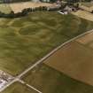
For other elements of the Mains of Huntingtower cropmark complex, see NO02NE 39, NO02NE 86, NO02NE 87, NO02NE 100, NO02NE 151, NO02SE 27, NO02SE 66 and NO02SE 67.
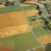
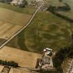
NO 056 227. The course of the Roman road is generally accepted as following the Gask Ridge along the present road. It then appears to have turned NE to cross the River Tay at Bertha (NO02NE 25).
Crawford (1949) and Margary (1957) both comment that there is no certain trace of the Roman road on this map sheet, Margary observing that it may have gone NE towards Tibbermore and the next fort at Bertha, which is situated by the River Tay, two and a half miles N of Perth. Crawford quotes the recording by Pennant of a rhomboid entrenchment below the manse at Tibbermore. Although such a shape is suggestive of a Roman fort or camp, and Crawford notes a short stretch of bank which would complete the shape, there is no evidence to point to age. Additionally, despite the fact that the NW and SE sides of the rhomboid are parallel to the presumed alignment of the road in this area and would take it past the medieval castle of Huntintower, as Roy (1747-55) suggested, Flt Lt Bradley investigating from the air and on the ground in 1941 saw nothing here which Crawford considers could be regarded as certain.
O G S Crawford 1949; I D Margary 1957; MSS notes and photographs, Information from Flt Lt Bradley.
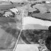
NO 0500 2192 to NO 0514 2208 There is no trace of the road (WDJ).
NO 0514 2208 to NO 0759 2458 There is no trace of the road across arable and pasture (SFS).
NO 0568 2264 trace of a low flat topped mound 7m wide and 0.2m high (SFS).
NO 0759 2458 to NO 0785 2491 The course is shown on OS Record 6 inch map (Crawford).
There is no trace of the road (WDJ).
NO 0798 2497 to NO 0807 2499 The course is shown on OS Record 6 inch map (Crawford).
There is no trace of the road (WDJ).
Visited by OS (WDJ) 1 November 1965, (SFS) April 1975.
Information from O G S Crawford 1940.
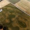
NE of the enclosures noted on NO02SE 34, a double line of pits runs towards the narrow defile W of Huntingtower Castle. As the lines approach the castle, the southern one changes its character; the large pits give way to a line of small pits. These features may be interpreted as the quarry pits of the Roman road (RR 7). (Site 4a on map - fig. 1).
G Barclay 1983.
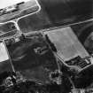
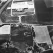
The current edition of the 1:10 000 OS map (1985) shows the Roman road passing to the W and N of Huntingtower Quarry, whereas the field sheet shows the course running S and E of the quarry. Confirmation of the former course is to be found in the aerial photographs of the area.
Information from RCAHMS (MW) 23 March 2000.
Scheduled as [part of] 'Mains of Huntingtower, henges, enclosures, pits and road WSW of... the remains of a neolithic henge, two prehistoric enclosures, five prehistoric roundhouses, dispersed groups of pits and a broadly-parallel alignment of pits representing a Roman road [surviving] as a complex group of buried archaeological features... on a river terrace in cultivated land to the north-west of Perth, 1km south of the River Almond and at 35m above sea level.'
Information from Historic Scotland, scheduling document dated 25 November 2008.

