
Pricing Change
New pricing for orders of material from this site will come into place shortly. Charges for supply of digital images, digitisation on demand, prints and licensing will be altered.
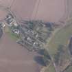
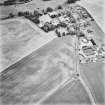
Forteviot Parish Church And Kirkyard


Burial Ground (Medieval), Carved Stone (Medieval), Church (Medieval)
Site Name Forteviot Parish Church And Kirkyard
Classification Burial Ground (Medieval), Carved Stone (Medieval), Church (Medieval)
Alternative Name(s) Forteviot, Old Parish Church
Canmore ID 79662
Site Number NO01NE 74
NGR NO 05144 17480
Datum OSGB36 - NGR
Permalink http://canmore.org.uk/site/79662


- Council Perth And Kinross
- Parish Forteviot
- Former Region Tayside
- Former District Perth And Kinross
- Former County Perthshire
NO01NE 74.00 05144 17480
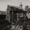
NO01NE 74.01 NO 05127 17488 Session House
See also NO01NE 10 and NO01NE 11. For Forteviot, Old Parish Church (NO c. 050 174), see NO01NE 12. For associated manse (NO 0522 1740), see NO01NE 40.00.
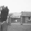
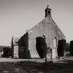
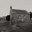
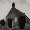
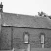
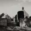
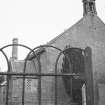
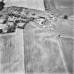
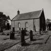
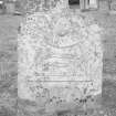
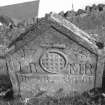
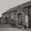
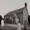
The parish church of Forteviot stands in a rectangular kirkyard on a terrace above, and to the E of, the Water of May. The present building (a short rectangular structure with a porch on the N) is of 18th-century date. The kirkyard, which has been extended to the S, contains numerous 18th-century gravestones, the oldest examples noted bearing the dates 1729, 1730 and 1758.
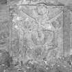
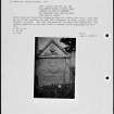
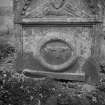
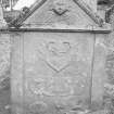
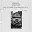
Leaning against the E wall of the porch is an irregularly-shaped fragment of sandstone, 0.75m long, 0.5m high and 0.15m thick. One edge bears a panel of key-pattern decoration, 0.28m in length.
Visited by RCAHMS (JRS, IF), 25 October 1995
NMRS B80026/po.
Ground Survey (4 August 2008 - 24 August 2008)
NO 0514 1748 A small-scale topographic survey consisting of c1200 points was conducted, 4–24 August 2008, in the area of the churchyard immediately surrounding the church to investigate a small rise in the ground to the S of the church. Additional data processing is required but it seems likely that a detailed close-interval topographic survey and potentially some geophysical survey will be needed in order to investigate this feature further.
www.gla.ac.uk/archaeology/research/projects/SERF
Archive: RCAHMS
Funder: British Academy, Historic Scotland, Department of Archaeology University of Glasgow and Society of Antiquaries of Scotland
Jeremy Huggett (Department of Archaeology, University of Glasgow), 2008
Excavation (1 August 2011 - 21 August 2011)
NO 05144 17480 As part of the SERF project two trenches were excavated, 1–21 August 2011, in the Forteviot Churchyard. One, a narrow trench situated at the E end of the church, revealed a series of structures and building phases relating to the church. These included the foundations of late 18th- or early 19th-century external stairs, the foundations of the 1778 church building, and at least two phases of medieval building. These phases included what is interpreted as a stone medieval foundation wall and part of a structure added onto the E end later in the medieval period. Finds of stone slates and decorated window glass suggest the medieval church building was a substantial and impressive structure.
The second trench, located in an unused cemetery plot in the modern extension to the graveyard, uncovered a previously unknown cemetery of up to seven W E oriented graves, as well as undated oval pits and one possible timber slot trench. The graves and other cut features were sealed by a 1m deep overburden of soil containing mainly modern midden material, possibly ‘night soils’ dumped from the nearby manse. Each grave consisted of simple earth-cut pits. A number of human teeth and heavily eroded bone fragments were found in two of the graves, confirming that the head was placed at the W end of the graves. Although not fully excavated, two possible graves had a rough stone slab capping; one of these was partially chisel-worked. The largest grave cut had a circular posthole at its SE corner, which resembled the features surrounding the central burials in the conjoined square barrows excavated outside Forteviot in 2007 (NO01NE 29).
The structural timber-beam slot and linear arrangement of small oval pits were closely associated with the graves. The timber-beam slot had a posthole at one end, indicating a possible structural function. It was aligned W–E and was seemingly respected by the graves, but did not clearly act as a burial enclosure, and remains undated.
Archive: University of Glasgow and RCAHMS (intended)
Funder: Historic Scotland and University of Glasgow
University of Glasgow, 2011

