
Scheduled Maintenance
Please be advised that this website will undergo scheduled maintenance on the following dates: •
Tuesday 3rd December 11:00-15:00
During these times, some services may be temporarily unavailable. We apologise for any inconvenience this may cause.
Forteviot


Timber Enclosure (Neolithic)
Site Name Forteviot
Classification Timber Enclosure (Neolithic)
Canmore ID 26559
Site Number NO01NE 28
NGR NO 05337 16888
NGR Description centred on 05337 16888
Datum OSGB36 - NGR
Permalink http://canmore.org.uk/site/26559


First 100 images shown. See the Collections panel (below) for a link to all digital images.
- Council Perth And Kinross
- Parish Forteviot
- Former Region Tayside
- Former District Perth And Kinross
- Former County Perthshire
NO01NE 28 053 169.
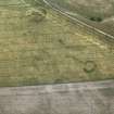
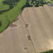
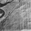
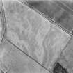
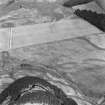
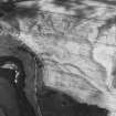
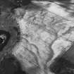
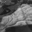
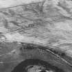
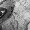
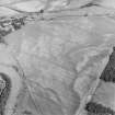
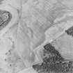
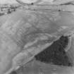
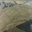
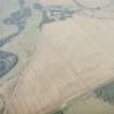
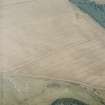
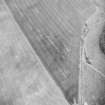
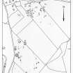
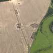
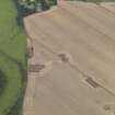
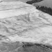
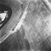
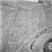
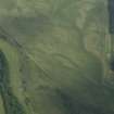
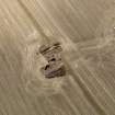
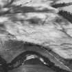
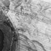
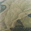
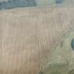
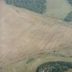
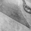
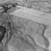
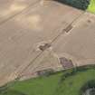
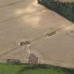
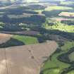
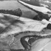
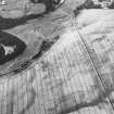
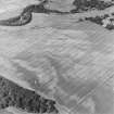
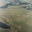
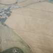
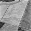
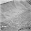
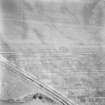
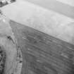
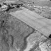
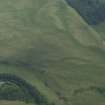
A group of archaeological features, not necessarily closely related, has been revealed by aerial photography S of Forteviot. The site occupies ground with a gentle northward slope, bounded on the W by a prominent scarp, falling to the Water of May.
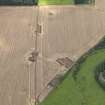
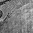
The most remarkable feature is a subcircular enclosure defined by a palisade; it measures about 265m N-S by 220m, an area of some 6ha (15 acres). The individual post-pits are for the most part quite distinct: save for a few gaps, the circuit is seen to be largely complete, except on the W, where it approaches the scarp already mentioned. Whether the palisade originally continued along the edge of the scarp, or whether a little has been lost to erosion is not now apparent. An 'avenue', or approach way, occurs on the N side of the enclosure, consisting of two rows, each of eight addiitonal posts. These two rows are about 6m apart, and extend for some 35m (C/f Meldon Bridge: NT24SW 46).
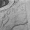
Within the circuit, aerial photographs show numerous small pock-marks, some of which may well relate to small pits, but no certain identification can be offered without excavation. However, six structures, or groups of structures, are visible as crop marks, lying both within and outside the enclosure, and should not necessarily be assumed to be contemporary with it. (For details of these, see NO01NE 30-35.)
J K St Joseph 1976; 1978.
Similar avenues approaching large pit-defined enclosures have been noted at Leadketty, Perthshire (NO01NW 40), Meldon Bridge, Peeblesshire (NT24SW 46) and Dunragit, Wigtownshire (NX15NW 76).
Information from RCAHMS (ARG), 23 January 1998.
Aerial Photographic Transcription (16 May 1991 - 11 June 1991)
An aerial transcription was produced from oblique aerial photographs. Information from Historic Environment Scotland (BM) 31 March 2017.
Excavation (2 August 2010 - 22 August 2010)
NO 0534 1690 Two areas of the large palisaded enclosure were investigated 2–22 August 2010. One trench, 40 x 10m, revealed an alignment of six postholes in the SE end of the enclosure. These substantial postholes, some up to 1m in diameter and over 1m deep, were similar to those found during the excavation of the avenue in 2007. In most cases ramps were found with the postholes. The fills of each of the postholes were distinct, suggesting differing treatments of individual posts over time. To the E of this alignment were the remains of a much later road, recorded on the 1st Edition OS map.
The second trench explored an area between the avenue and the NW perimeter of the enclosure. As recorded
elsewhere, the palisade was defined by large postholes, many with traces of ramps. A single fragment of possibly Neolithic pottery was recovered from one of the postholes. A large but shallow clay-lined pit was recorded at the junction between the avenue and the interior of the enclosure. This pit may have contained water and if contemporary with the enclosure would have affected access into the interior.
Archive: Currently University of Glasgow and RCAHMS (intended)
Funder: Historic Scotland, University of Glasgow and University of Aberdeen
Project (May 2010 - August 2010)
A series of geophysical surveys were carried out over four targeted areas in the main prehistoric ritual complex at Forteviot in May–August 2010. The surveys aimed to confirm the survival of archaeological features identified by aerial photography and identify any other areas of archaeological interest.
NO 0524 1699 Double ditch enclosure A multi-technique geophysical survey was carried out over this feature to assess the capabilities of four near-surface geophysical techniques (earth resistance, gradiometry, ground penetrating radar and EM38) as part of a PhD project. The two ditches of the enclosure were detected by the gradiometer survey. The earth resistance survey detected only the outer ditch of the enclosure and a central pit. The EM38 survey detected the structure after the stripping of the topsoil. The partial GPR survey successfully detected the targeted ditch.
NO 0534 1705 Henge The gradiometer survey carried out in this area clearly detected the wide ditches associated with this structure as well as the central pit.
NO 0547 1746 Square barrows The gradiometer survey carried out in this area identified the central grave of the W barrow but it did not detect any ditches.
NO 0543 1695 Palisaded enclosure A gradiometry survey carried out across the NE corner of the palisaded enclosure suggested the enclosure may have had an accompanying linear ditch in places, and that several of the postholes were burnt in situ. A notable large dipolar anomaly was recorded within the interior of the enclosure.
Archive: RCAHMS (intended)
Funder: NERC, Historic Scotland and University of Glasgow
University of Glasgow, 2010
Magnetometry (May 2010 - August 2010)
NO 0524 1699 Double ditch enclosure. A multi-technique geophysical survey was carried out over this feature to assess the capabilities of four near-surface geophysical techniques (earth resistance, gradiometry, ground penetrating radar and EM38) as part of a PhD project. The two ditches of the enclosure were detected by the gradiometer survey.
NO 0534 1705 Henge. The gradiometer survey carried out in this area clearly detected the wide ditches associated with this structure as well as the central pit.
NO 0547 1746 Square barrows. The gradiometer survey carried out in this area identified the central grave of the W barrow but it did not detect any ditches.
NO 0543 1695 Palisaded enclosure. A gradiometry survey carried out across the NE corner of the palisaded enclosure suggested the enclosure may have had an accompanying linear ditch in places, and that several of the postholes were burnt in situ. A notable large dipolar anomaly was recorded within the interior of the enclosure.
Archive: RCAHMS (intended)
Funder: NERC, Historic Scotland and University of Glasgow
University of Glasgow, 2010
Magnetic Susceptibility (May 2010 - August 2010)
NO 0524 1699 Double ditch enclosure A multi-technique geophysical survey was carried out over this feature to assess the capabilities of four near-surface geophysical techniques (earth resistance, gradiometry, ground penetrating radar and EM38) as part of a PhD project. The EM38 survey detected the structure after the stripping of the topsoil.
Archive: RCAHMS (intended)
Funder: NERC, Historic Scotland and University of Glasgow
University of Glasgow, 2010
Ground Penetrating Radar (May 2010 - August 2010)
NO 0524 1699 Double ditch enclosure A multi-technique geophysical survey was carried out over this feature to assess the capabilities of four near-surface geophysical techniques (earth resistance, gradiometry, ground penetrating radar and EM38) as part of a PhD project. The partial GPR survey successfully detected the targeted ditch.
Archive: RCAHMS (intended)
Funder: NERC, Historic Scotland and University of Glasgow
University of Glasgow, 2010
Resistivity (May 2010 - August 2010)
NO 0524 1699 Double ditch enclosure A multi-technique geophysical survey was carried out over this feature to assess the capabilities of four near-surface geophysical techniques (earth resistance, gradiometry, ground penetrating radar and EM38) as part of a PhD project. The earth resistance survey detected only the outer ditch of the enclosure and a central pit.
Archive: RCAHMS (intended)
Funder: NERC, Historic Scotland and University of Glasgow
University of Glasgow, 2010
Note (11 April 2014)
Excavation revealed that this enclosure was defined by large timber posts and not by the continuous bedding trench of a palisade. As such the classification has been changed from palisaded enclosure to timber enclosure.
Information from RCAHMS (KMM) 11 April 2014

