
Pricing Change
New pricing for orders of material from this site will come into place shortly. Charges for supply of digital images, digitisation on demand, prints and licensing will be altered.
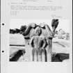
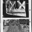
Fossoway, Old Parish Church And Graveyard


Burial Ground (Period Unknown), Church (Period Unknown)
Site Name Fossoway, Old Parish Church And Graveyard
Classification Burial Ground (Period Unknown), Church (Period Unknown)
Canmore ID 26531
Site Number NO00SW 6
NGR NO 0158 0192
Datum OSGB36 - NGR
Permalink http://canmore.org.uk/site/26531


- Council Perth And Kinross
- Parish Fossoway (Perth And Kinross)
- Former Region Tayside
- Former District Perth And Kinross
- Former County Kinross-shire
NO00SW 6 0158 0912
(NO 0158 0192) Fossoway Church (NR) (remains of)
OS 1:10,000 map, (1982)
The church at Fossoway, like that at Tulliebole (NO00SE 8) was taken down in 1729, and the manse and glebe were sold. A new church, replacing the two, was then built at Tulliebole.
OSA 1796.
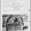
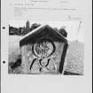
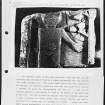
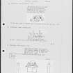
The outline of this church is still evident on the ground by the collapsed rubble remains of its walls, except for the E half of the N wall, which has been entirely removed. It measured 17.0m E-W by 5.5m transversely. A headstone dated 1694 is among several in the graveyard.
Revised at 1:2500.
Visited by OS (W D J) 20 December 1967.

