
Pricing Change
New pricing for orders of material from this site will come into place shortly. Charges for supply of digital images, digitisation on demand, prints and licensing will be altered.
Crieff To Dalnacardoch Military Road


Military Road (18th Century)
Site Name Crieff To Dalnacardoch Military Road
Classification Military Road (18th Century)
Alternative Name(s) River Braan; Craig Hulich; Ballinlochan; Fender Burn; North Amulree; Glen Cochill; Newton Of Ballinreigh
Canmore ID 84890
Site Number NN93NW 14
NGR NN 9117 3900
NGR Description NN 9000 3655 to NN 9099 3999
Datum OSGB36 - NGR
Permalink http://canmore.org.uk/site/84890


- Council Perth And Kinross
- Parish Little Dunkeld
- Former Region Tayside
- Former District Perth And Kinross
- Former County Perthshire
NN93NW 14.00 9000 3655 to 9099 3999 MR 3 (Formerly LIN 501)
General Wade's Military Road (NAT)
OS map 1:10000 (1982)
NN93NW 14.01 9101 3785 Newton of Ballinreigh Bridge.
NN93NW 14.02 9101 3786 Newton of Ballinreigh Culvert.
NN93NW 14.03 9095 3810 Glenfender Burn Bridge.
NN93NW 14.04 9110 3922 Glen Cochill Culvert.
NN93NW 14.05 9110 3955 Cochill Burn Culvert.
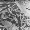
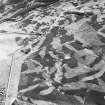
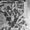
To the N of the River Braan, the military road ascends the shoulder of Craig Hulich, having passed through the steading of Ballinlochan farmhouse. There is an interesting zig-zag on this route and distinct traces of the Wade bridge (NN93NW 14.03) traversing the Fender Burn at NN 9095 3810). Although the stone is rotten, part of the piers is still extant. The road then crosses the modern road and heads N to the E of it.
J B Salmond 1938.
NN 9000 3655 - 9008 3673 modern road on course.
NN 9008 3673 - 3715 3683 traces of terracing effect N and S of river. Fordable.
NN 3715 3683 - 9018 3688 no trace.
NN 9018 3688 - 9033 3709 farm track on line.
NN 9033 3709 - 9074 3727 road visible as slight partially grass-covered track in slight hollow-way or terrace c.5m wide with bank or wall visible in places on S side.
NN 9074 3727 - 9099 3803 road visible as grass-covered metalled track running between banks or walls 5 to 6m apart.
NN 9101 3786 - culvert 5m wide (NN93NW 14.02).
NN 9099 3803 - 9088 3840 course of road running between old field walls.
NN 9095 3810 - springing of old bridge NN93NW 14.03).
NN 9088 3840 - 9100 3843 road visible as disused grass-covered track 5.5m wide.
NN 9100 3843 - 9122 3863 metalled track on line.
NN 9122 3863 - 9123 3867 grass-covered track between banks 6m apart.
NN 9123 3867 - 9123 3873 in dense afforestation.
NN 9123 3873 - 9123 3875 partially grass-covered track.
NN 9123 3875 - 9110 3947 road visible as terraced track 4 to 5m wide.
NN 9110 3922 - culvert (NN93NW 14.04).
NN 9110 3947 - 9110 3955 road visible as slight hollow running between banks c.5m apart.
NN 9110 3955 - springing of culvert c.5m wide (NN93NW 14.05).
NN 9110 3955 - 9099 3999 visible as slight heather-covered hollow 4m wide.
Visited by OS November 1970.
Wade's Road: Crieff - Dalnacardoch; road extant and in excellent state of preservation throughmost of the sheet.
Visited by OS (NKB) 22 October 1975.
To the N of the River Braan, the military road takes the form of a well-defined track, heading through the policies of Ballinlochan Farm as far as the remains of a bridge over the Fender Burn (NN93NW 14.03) at NN 9095 3810. The track becomes somewhat overgrown and rough to the N of this burn, A forestry plantation encroaches on the line for approximately 200 yards. The route then descends to the modern road at NN 912 395, crossing over it and then heading N to the E of it.
W Taylor 1976.
The Crieff to Dalnacardoch military road was built in 1730 by General Wade, and it survives as a well-made track flanked by earth-and-stone banks. It leaves the modern road at North Amulree and runs over the shoulder of the hill into Glen Fender and on into Glen Cochill. A well-made stone bridge (NN93NW 14.01) spans a burn at NN 9101 3785, but there is no indication of how the Glenfender Burn was crossed. The road overlies part of the field-system on the N side of Glen Fender (NN93NW 13.14) and appears to have provided the axis for the Improvement Period fields laid out along its NW side to the SSW of Newton of Ballinreigh.
Visited by RCAHMS (DCC) 8 December 1993.

