
Pricing Change
New pricing for orders of material from this site will come into place shortly. Charges for supply of digital images, digitisation on demand, prints and licensing will be altered.
Upcoming Maintenance
Please be advised that this website will undergo scheduled maintenance on the following dates:
Thursday, 9 January: 11:00 AM - 3:00 PM
Thursday, 23 January: 11:00 AM - 3:00 PM
Thursday, 30 January: 11:00 AM - 3:00 PM
During these times, some functionality such as image purchasing may be temporarily unavailable. We apologise for any inconvenience this may cause.
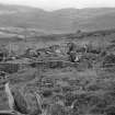
Black Castle Of Strathgarry


Settlement (Period Unassigned)
Site Name Black Castle Of Strathgarry
Classification Settlement (Period Unassigned)
Canmore ID 25858
Site Number NN86SE 8
NGR NN 8897 6317
Datum OSGB36 - NGR
Permalink http://canmore.org.uk/site/25858


- Council Perth And Kinross
- Parish Blair Atholl
- Former Region Tayside
- Former District Perth And Kinross
- Former County Perthshire
NN86SE 8 8897 6317.
(Area: NN 888 633) A homestead consisting of a hut circle, measuring 83' x 72' over a wall 9'6" thick was investigated by RCAHMS in 1942. The back wall and the slope that results from the process of scooping jointly account for some 32' of the minor axis. The lowest course of the outer face of the wall remains for 47'; the wall here has been built of larger blocks on either face, with a core of smaller stones. A field wall of stones and turf adjoins the side of the hut at the end of this sector; its facing stones are similar to those of the hut wall and the two walls seem to be continuous construction.
V G Childe and A Graham 1943.
NN 890 632: An oval dun.
R W Feachem 1963.
NN 8897 6317: The slight remains of an oval homestead c. 26.0m E-W x 21.0m N-S with a possible entrance in the NE The remains are so dilapidated and hidden by grass that the width of the wall, c 2.5m, is only conjectural; a portion of the outer wall face is visible on the W side. The slope resulting from scooping (Childe and Graham 1943) may be caused by the wall of the dun falling into the interior.
It is known locally as the "Black Castle of Strathgarry".
Surveyed at 1:2500.
Visited by OS (W D J) 27 March 1968.
'Black Castle of Strathgarry', an oval homestead set into the NE-facing slope, and now planted with conifers. The inner face is no longer visible in the heavily turfed wall, but several outer facing stones give overall measurements of 25.0m E-W by 21.0m N-S. A slight gap in the ENE may represent the entrance.
The field wall noted by Childe and Graham (1943) runs uphill from the W arc. It is overlaid 8.0m from the homestead by a late turf dyke running N-S, but further up the hill, it too can be seen to be a relatively late hill dyke.
Surveyed at 1:10,000.
Visited by OS (J M) 7 November 1974.
Field Visit (19 October 1942)
This site was included within the RCAHMS Emergency Survey (1942-3), an unpublished rescue project. Site descriptions, organised by county, vary from short notes to lengthy and full descriptions and are available to view online with contemporary sketches and photographs. The original typescripts, manuscripts, notebooks and photographs can also be consulted in the RCAHMS Search Room.
Information from RCAHMS (GFG) 10 December 2014.
Field Visit (23 July 1962)

