
Pricing Change
New pricing for orders of material from this site will come into place shortly. Charges for supply of digital images, digitisation on demand, prints and licensing will be altered.
Acharn, Mill


Watermill (Period Unassigned)
Site Name Acharn, Mill
Classification Watermill (Period Unassigned)
Alternative Name(s) Acharn, The Old Mill; Lochtayside Crofts; Acharn Village
Canmore ID 128676
Site Number NN74SE 35
NGR NN 75600 43839
Datum OSGB36 - NGR
Permalink http://canmore.org.uk/site/128676


- Council Perth And Kinross
- Parish Kenmore (Perth And Kinross)
- Former Region Tayside
- Former District Perth And Kinross
- Former County Perthshire
NN74SE 35 75600 43839
The Old Mill [NAT]
OS 1:2500 map, 1981.
Visited and photographed by J R Hume, University of Strathclyde, 7 June 1976.
NMRS, MS/749/95.
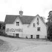
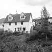
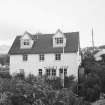
(Location cited at NN 756 438). Mill, Acharn, early 19th century. A 2-storey and attic building, converted to a craft centre. The 6-spoke overshot wheel, 3ft (0.91m) wide by 12ft (3.66m) diameter, with iron rings and axle, wooden spokes and buckets, has been retained.
J R Hume, 1977.

