
Pricing Change
New pricing for orders of material from this site will come into place shortly. Charges for supply of digital images, digitisation on demand, prints and licensing will be altered.
West Cowden Farm, 'stone Circle'


Cup Marked Stone (Prehistoric), Stone Setting (Neolithic) - (Bronze Age)
Site Name West Cowden Farm, 'stone Circle'
Classification Cup Marked Stone (Prehistoric), Stone Setting (Neolithic) - (Bronze Age)
Alternative Name(s) Roman Stone; Dalginross; Penfillan
Canmore ID 24856
Site Number NN72SE 5
NGR NN 7744 2064
Datum OSGB36 - NGR
Permalink http://canmore.org.uk/site/24856


- Council Perth And Kinross
- Parish Comrie (Perth And Kinross)
- Former Region Tayside
- Former District Perth And Kinross
- Former County Perthshire
NN72SE 5 7744 2064
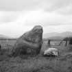
(NN 7744 2064) Roman Stone (NR)
OS 6" map (1901).
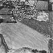
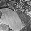
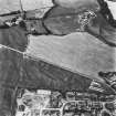
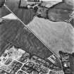
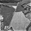
For surrounding Roman temporary camp, see also NN72SE 1.
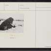
A huge stone leaning over sharply to the east; vertical height 6'4" and 21'6" in basal girth. 2' from its east side is a block of whinstone about 1'10" thick and measuring 3'10" by 2'10", and about 6' to its east there is a stone about 18" high, covered with 22 cups. The three stones now lie abreast in a straight line and it is now impossible to tell what were their original positions or if they were forming a circle.
F R Coles 1911.
As described above. The name 'Roman Stone' is known locally, and applies to the largest.
Re-surveyed at 1/2500.
Visited by OS (RD), 1 December 1966.
Scheduled with NN72SE 1, NN72SE 2 and NN72SE 21 as 'Dalginross, Roman fort, annexe, camp and stone circle 200m S of Penfillan... the buried remains of a complex of Roman military remains, appearing as... cropmarks on oblique aerial photographs... across the arable fields immediately to the southwest of Dalginross and to the east of the Water of Ruchill.'
Information from Historic Scotland, scheduling document dated 23 November 2010.
Field Visit (19 August 1942)
This site was included within the RCAHMS Emergency Survey (1942-3), an unpublished rescue project. Site descriptions, organised by county, vary from short notes to lengthy and full descriptions and are available to view online with contemporary sketches and photographs. The original typescripts, manuscripts, notebooks and photographs can also be consulted in the RCAHMS Search Room.
Information from RCAHMS (GFG) 12 December 2014

