
Pricing Change
New pricing for orders of material from this site will come into place shortly. Charges for supply of digital images, digitisation on demand, prints and licensing will be altered.
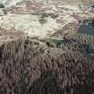
Strathmashie Forest, Tirfadoun South 2


Farmstead (Period Unassigned)
Site Name Strathmashie Forest, Tirfadoun South 2
Classification Farmstead (Period Unassigned)
Canmore ID 276832
Site Number NN59SE 36
NGR NN 5853 9281
Datum OSGB36 - NGR
Permalink http://canmore.org.uk/site/276832

- Council Highland
- Parish Laggan
- Former Region Highland
- Former District Badenoch And Strathspey
- Former County Inverness-shire
NN59SE 36 5853 9281
The remains of 4 rectangular structures were recorded here during a detailed desktop and walkover survey of Strathmashie Forest ahead of a proposed heritage trail. Enough archaeological features were found to make the trail worthwhile. The northernmost feature consists only of a rectangular slightly sunken area. It measures approximately 7m x 3m. Around 8m to the S is are the remains of a building measuring 9m x 3m. The drystone walls are masked in areas by turf and vegetation cover. South of this building is another, which measures 5m x 2.5m and is defined by shallow turf banks, with occassional stones showing through. To the W of this are the remains of a larger building, 12m x 4m. It is composed of 2 parts, the first measuring 4m x 2.5m and a less-defined section, 9.5m x 4m. A slightly curving dyke extends in a N-S direction for around 20m to the E of the 4 structures.
D Sneddon 2005

