
Pricing Change
New pricing for orders of material from this site will come into place shortly. Charges for supply of digital images, digitisation on demand, prints and licensing will be altered.
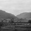
Lochearnhead, Ogle Burn, Railway Viaduct


Railway Viaduct (20th Century)
Site Name Lochearnhead, Ogle Burn, Railway Viaduct
Classification Railway Viaduct (20th Century)
Canmore ID 24124
Site Number NN52SE 14
NGR NN 58891 24080
NGR Description From NN 58814 24006 to NN 58952 24105
Datum OSGB36 - NGR
Permalink http://canmore.org.uk/site/24124


- Council Stirling
- Parish Balquhidder
- Former Region Central
- Former District Stirling
- Former County Perthshire
NN52SE 14 58891 24080
Not to be confused with railway bridge at NN 5879 2398, for which see NN52SE 30.
This viaduct formerly carried the Crieff-Lochearnhead-Balquhidder branch of the Caledonian Rly over the Ogle Burn.
Information from RCAHMS (RJCM), 18 June 1998.
NN52SE 14 58884 24075
Lochearnhead Viaduct: Disused on date of visit.
Visited and photographed by J R Hume, University of Strathclyde, 9 May 1974.
Information from NMRS MS/749/124.
A curved nine arch concrete railway viaduct situated at the N end of Lochearnhead village crossing the Ogle Burn.
The viaduct retains metail rails on the parapet. Short section across the A84 trunk road has been removed.
Visited by RCAHMS (DE,GL), 20 April 2007

