
Pricing Change
New pricing for orders of material from this site will come into place shortly. Charges for supply of digital images, digitisation on demand, prints and licensing will be altered.
Fort William


Town (Period Unassigned)
Site Name Fort William
Classification Town (Period Unassigned)
Alternative Name(s) Maryburgh
Canmore ID 106439
Site Number NN17SW 40
NGR NN 10283 73600
NGR Description Centred NN 10283 73600
Datum OSGB36 - NGR
Permalink http://canmore.org.uk/site/106439


- Council Highland
- Parish Kilmallie
- Former Region Highland
- Former District Lochaber
- Former County Inverness-shire
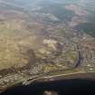
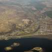
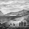
FORT WILLIAM (an Gearastan - the Garrison) Strategically sited at the head of the Great Glen where the Rivers Lochy and Nevis flow into Loch Linnhe, Fort William lies at a junction of mountains and lochs overshadowed by the moody bulk of Ben Nevis. The town was founded by the English in the 17th century, and outsiders have continued to have a significant impact on its development - tourists and climbers today, rather than the soldiers whose fortifications have been all but swept away, but something of a frontier post atmosphere lingers. Uninspired planning and design have done little to improve the appearance of this doughty, predominantly brown and grey West Highland town, where supermarket, garage and fast food stops have colonised the reclaimed ground of An Aird as backdrops to the historic site of the old fort, and the traffic-scarred waterfront is overlooked by the unsightly backsides of hotels and tenements. The expansion of Caol, Inverlochy and Corpach as suburbs of Fort William testifies to its industrial development in the 20th century as a centre for aluminium and wood processing.
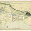
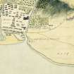
The Fort The garrison of Inverlochy was sited on a triangular piece of land now sandwiched between two roundabouts at the mouth of the River Nevis (diverted early 1970s), just a short distance to the south of the medieval castle of Inverlochy (see p.23 ). Its origin was the small, loosely pentagonal turf and timber fort with wattle ramparts that was thrown up in 1654 by General George Monk to hold about 250 of Cromwell's new model army. After the Restoration this Cromwellian fort fell into disuse and a new fort, named after William III and capable of accommodating 1,000 troops, was raised over the foundations. It commanded an important waterway at the end of the Great Glen, completing the chain that includes Forts George and Augustus. Earthworks were begun in 1690 and the stone structure in c.1698, with 20 ft-high walls, moat, corner turrets and sallyport. It was remodelled by Dugal Campbell, 1746, following a fiveweek Jacobite siege. The fort was garrisoned until 1854 (by this time mainly to discourage smugglers) and eventually largely dismantled in 1864, part being given over to housing and allotments. Engine sheds, goodsyard and the RCAHMS railway line came next, with the purchase of the site by the West Highland Railway Co in 1889. The surviving block of officers' quarters was occupied by railwaymen until 1935, and finally demolished in 1948. Today, only sections of the north and west ramparts of the fort survive on the site, incorporating the sallyport and one demi-bastion.
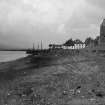
The Town The first reference to a settlement here appears in 1597, although this encampment is unlikely to have amounted to much more than a few scattered dwellings. A sutlery grew up round the fort (named Maryburgh, after the queen, in the late 17th century) 'of timber, boards and turf' so they could be easily destroyed if rebellion broke out, as indeed they were on the governor's orders following the Jacobite siege of 1746. Later known as Gordonsburgh, the settlement was remodelled by John Baxter in the late 18th century, to become a principal commercial centre with a square at an important junction of routes in the heart of Lochaber. Described by John Leyden c.1800 as 'an elegant village, much superior to Oban in regularity and beauty', it was renamed Duncansburgh in 1834 , after the new feu superior, Sir Duncan Cameron of Fassifern, and became established as the Burgh of Fort William in 1874. The 19th century saw the town assume an air of comfortable gentility, with commodious villas appearing on land above the High Street and spreading out along Achintore's waterfront. A preference for grey, rockfaced granite became a familiar characteristic. In 1896, a pioneering hydroelectric scheme made Fort William the first town in Britain to have its streets and houses lit by electricity from its own water power. The coming of the Railway to the West Highlands had a significant impact on Fort William, obliterating part of the disused fort and effectively cutting off its heart from the waterfront to gain crucial access to the town pier and Loch Linnhe. The station stood west of Gordon Square near the shore, a brick structure with stone detailing and leaded lights in the Glasgow Style, demolished in 1975 to make way for the main road. The line was opened by the West Highland Railway Co in 1894; engineers Forman & McCall. In 1895 a connecting spur to Banavie opened and the Mallaig extension was begun two years later, opening in 1901.
Taken from "Western Seaboard: An Illustrated Architectural Guide", by Mary Miers, 2008. Published by the Rutland Press http://www.rias.org.uk

NN17SW 40 centred 10283 73600
Non-Guardianship Sites Plan Collection, DC23754- DC23801, 1719,1719,1733,1740,1744- 1746,1751,1769,
1982,1815,1818,1821,1934- 1935.
(Undated) information in NMRS.

