
Balure


Burial Cairn (Bronze Age)
Site Name Balure
Classification Burial Cairn (Bronze Age)
Alternative Name(s) Balure 3; East
Canmore ID 23102
Site Number NM84SE 7
NGR NM 89750 41400
Datum OSGB36 - NGR
Permalink http://canmore.org.uk/site/23102


- Council Argyll And Bute
- Parish Ardchattan And Muckairn (Argyll And Bute)
- Former Region Strathclyde
- Former District Argyll And Bute
- Former County Argyll
NM84SE 7 8975 4140
(NM 8975 4140) Cairn (NR)
OS 1:10,000 map, (1976).
See also NM84SE 6 and NM84SE 7.
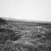
This is the easternmost of a group of three cairns [NM84SE 6, NM84SE 7, NM84SE 8 ]. It measures 12 metres in diameter and 0.5 meters above the present ground level. A trial excavation carried out in 1963 by the Lorn Archaeol Soc revealed that the visible cairn material represents only a small proportion of the whole. The excavation had to be abandoned because of the waterlogged nature of the ground and the cairn was restored as nearly as possible to its previous state.
M Kay 1963; RCAHMS 1975, visited April 1967.
As described.
Surveyed at 1:2500.
Visited by OS (RD) 8 November 1971.
Field Visit (April 1967)
About 750 m SW of Balure farmhouse there is a group of three cairns, situated on a bleak heather-covered moss at a height of about 12 m OD.
(3) NM 897 414. The easternmost cairn, 135 m ESE of (2), measures 12 m in diameter and 0·5 m high above present ground level. A trial excavation, however, carried out in 1963 by members of the Lorn Archaeological Society (DES 1963, 8; MS 64/1), revealed that the visible cairn material represents only a comparatively small proportion of the whole, the remainder being hidden by a layer of peat estimated to be at least 1.5 m thick. The cairn material, consisting of water-worn stones of smallish size, shells, quartz pebbles and soil, was removed to a depth of about 0·8 m below turf-level, but further investigation became impossible because of the waterlogged condition of the site. Probing, however, suggested that the cairn may originally have measured as much as 3 m in height and 18 m in diameter. At the end of the investigation the cairn was restored, as far as possible, to its previous state.
RCAHMS 1975, visited April 1967.

