
Scheduled Maintenance
Please be advised that this website will undergo scheduled maintenance on the following dates: •
Tuesday 3rd December 11:00-15:00
During these times, some services may be temporarily unavailable. We apologise for any inconvenience this may cause.
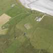
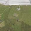
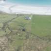
Tiree, Kirkapol, Cladh Orain


Burial Ground (Period Unassigned), Chapel (Period Unassigned), Cross (Period Unassigned), Cross Slab(S) (Early Medieval)
Site Name Tiree, Kirkapol, Cladh Orain
Classification Burial Ground (Period Unassigned), Chapel (Period Unassigned), Cross (Period Unassigned), Cross Slab(S) (Early Medieval)
Alternative Name(s) Cladh Beg; Kirkapoll
Canmore ID 21522
Site Number NM04NW 28
NGR NM 0423 4726
Datum OSGB36 - NGR
Permalink http://canmore.org.uk/site/21522


- Council Argyll And Bute
- Parish Tiree
- Former Region Strathclyde
- Former District Argyll And Bute
- Former County Argyll
NM04NW 28 0423 4726
See also NM04NW 2.
(NM 0423 4726) Cladh Orain (NAT)
OS 1:10,000 map, (1976)
Cladh Orain (NR)
OS 6"map, Argllshire, 2nd ed., (1900)
Cladh Orain: A small burial-ground in which are the ruins of an old chapel (old parish church - NM04NW 2).
Name Book 1878.
Beveridge maintains that this is not Cladh Orain, but Cladh Beg.
E Beveridge 1903.
The RCAHMS also refer to this burial-ground as 'Cladh Beg'. In it are five grave-slabs or cross-slabs (all fully described) datable between the 14th and early 16th centuries. There is also an undecorated cruciform stone serving as a headstone. It measures 0.65m high by 0.35m wide across the arms. It is possible, but unlikely that this stone dates to the Early Christian period (See also NM04NW 9).
RCAHMS 1980; W Reeves 1854.

