
Fraserburgh Airfield


Airfield (20th Century)
Site Name Fraserburgh Airfield
Classification Airfield (20th Century)
Alternative Name(s) Cairnbulg Airfield; Inverallochy Airfield
Canmore ID 73873
Site Number NK06SW 26
NGR NK 0405 6443
NGR Description Centred NK 0405 6443
Datum OSGB36 - NGR
Permalink http://canmore.org.uk/site/73873


- Council Aberdeenshire
- Parish Rathen
- Former Region Grampian
- Former District Banff And Buchan
- Former County Aberdeenshire
NK06SW 26.00 centred 0405 6443
NK06SW 26.01 NK c. 0355 6413 Control Tower
NK06SW 26.02 Centred NK 03393 64237 Aircraft Hangar; Buildings; Air-raid shelters
NK06SW 26.03 Centred NK 0393 6383 Aircraft Hangars; Dispersal Bays; Buildings; Air-raid shelters
NK06SW 26.04 Centred NK 0458 6460 Aircraft Hangars; Dispersal Bays; Buildings
NK06SW 26.05 Centred NK 0355 6465 Military Camp
NK06SW 26.06 NK 02704 64537 Observation Post (Battle H.Q.)
See also:
NK06SW 29 Centred NK 02641 64292 Military Camp
NK06SW 30 NK 020 645 to NK 028 645 Military Camp
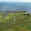
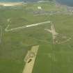
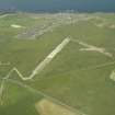
World War II airfield. Disused, part of one runway has sheds built on it.
Visible on air photographs AAS/93/15/G31/12-15 and AAS/93/15/G32/1-5, flown 11 November 1993. Copies held by Grampian Region SMR.
NMRS MS/712/6.
Airfield: built as a satellite of Peterhead airfield [Longside airfield: NK04NE 12.00 centred at NK 076 473], opening 6 December 1941.
Comprised: three dispersed sleeping sites, a communal area, and a technical site with one T2 hangar.
Closed at the end of June 1945, but was used by Aberdeen Gliding Club in the 1950's.
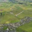
The two runways are now blocked by poultry houses and almost all the original buildings have been demolished, leaving only a few solitary huts and the parachute store.
NMRS, MS/2059.
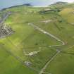
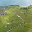
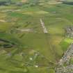
Fraserburgh Airfield also known as Inverallochy is situated on level ground immediately to the SW of the village of Inverallochy. The airfield consisted of three runways, a NE to SW, NW to SE and NNW to SSE in a standard plan and occupies an area of about 115 hectares.
The airfield which opened during 1941, is visible on RAF WW II vertical air photographs (NLA 57, 5001-5007, flown 21 February 1943), which show the northern part before the improvements of later 1943 to accommodate Operational Training Units (OTU).
Vertical air photographs taken in 1946 (106G/Scot/UK 108, 3003-3005, 4002-4006, flown 23 May 1946), reveal that additional aircraft hangars, buildings and air-raid shelters had been completed in the the dispersal areas. A series of air photographs taken in 1988 (All Scotland Survey [Jasair], 07 88 060-062, flown 6 May 1988) show that by this date most of the buildings had been removed and that some areas of the airfield were now being used for new housing estates.
Information from RCAHMS (DE), July 2006.

