Pricing Change
New pricing for orders of material from this site will come into place shortly. Charges for supply of digital images, digitisation on demand, prints and licensing will be altered.
Aberdeen, Grandhome House, Lodges And Gate
Gate (19th Century), Gate Lodge(S) (19th Century)
Site Name Aberdeen, Grandhome House, Lodges And Gate
Classification Gate (19th Century), Gate Lodge(S) (19th Century)
Alternative Name(s) Grandhome, Lodges; Grandhome Policies
Canmore ID 124692
Site Number NJ91SW 65
NGR NJ 90390 11904
NGR Description Centred NJ 90390 11904
Datum OSGB36 - NGR
Permalink http://canmore.org.uk/site/124692
- Council Aberdeen, City Of
- Parish Old Machar
- Former Region Grampian
- Former District City Of Aberdeen
- Former County Aberdeenshire
NJ91SW 65 centred 90390 11904
For Grandhome House (NJ 89849 11747), see NJ81SE 36.
North Lodge: NJ 90396 11916
South Lodge: NJ 90390 11897
OS (GIS) MasterMap, April 2009.
Project (1 October 2011 - 18 December 2011)
A desk-based assessment has been undertaken for land within a proposed development area at Grandhome, Aberdeenshire.
Forty-seven sites and features of cultural heritage interest have been identified within the proposed development area, ranging from the Neolithic to the Post-medieval period.
Information from H Gray – CFA Archaeology Ltd.
OASIS ID: cfaarcha1-423109
Desk Based Assessment (1 October 2011 - 18 December 2011)
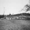
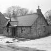
NJ 90390 11904 The Listed Buildings List records the lodges as comprising small twin lodges of 19th century date, constructed of granite, with granite piers and a flanking gate. Two small buildings annotated ‘Lodge’ are shown on the Ordnance Survey 1st Edition map (1869) on the north and south sides of a tree lined road leading to Grandholm House. A third building is shown on the Ordnance Survey 2nd Edition map (1901), to the south, but is not shown on the current Ordnance Survey map (2002). Two buildings are visible on aerial photographs from 1953 and 1966.
Information from H Gray – CFA Archaeology Ltd.
OASIS ID: cfaarcha1-423109


