
Pricing Change
New pricing for orders of material from this site will come into place shortly. Charges for supply of digital images, digitisation on demand, prints and licensing will be altered.
Suttie


Palisaded Enclosure (Period Unassigned)
Site Name Suttie
Classification Palisaded Enclosure (Period Unassigned)
Alternative Name(s) Wester Fintray; Kiln Cottage
Canmore ID 19500
Site Number NJ81NW 38.02
NGR NJ 81338 15809
Datum OSGB36 - NGR
Permalink http://canmore.org.uk/site/19500


- Council Aberdeenshire
- Parish Fintray
- Former Region Grampian
- Former District Gordon
- Former County Aberdeenshire
NJ81NW 38.02 81338 15809
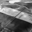
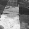
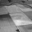
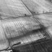
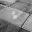
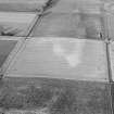
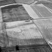
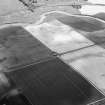
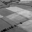
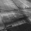
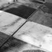
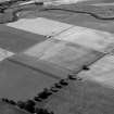
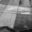
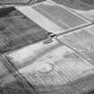
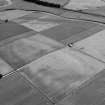
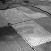
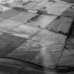
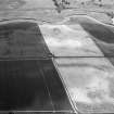
Cropmarks of a palisaded enclosure: the outer trace is possibly that of a ditch and the inner that of a palisade. The E half of the enclosure contains a putative open square feature, and the cropmarks, taken as a whole, may represent a homestead.
Information from Mrs M Greig (Grampian Regional Council), 24 April 1995.
List of Aberdeenshire Archaeological Service air photographic cover.
NMRS, MS/712/19, MS/712/21 and MS/712/29.
NJ 8105 1637 Following on from the substantial rescue excavations around Kintore between 2000 and 2004 (e.g. DES 2004, 15-16), the Kintore Landscape Project was established to place the results of the excavations within a wider landscape context.
The third phase of work took place at Wester Fintray Farm in October 2005, following work in 2004 and earlier in 2005, and comprised the machine-excavation of a series of linear slots across and within two cropmark enclosures (NJ81NW 53 and NJ81NW 38.2) with the specific aim of recovering dating evidence. Additionally, a grid excavation took place over the centre of the lithic scatter identified in 2004. All of the work was conducted by volunteers.
Sections were excavated across the ditches of both enclosures: NJ81NW 38.2 was broad with a flat base, measuring around 4.6m wide and 0.7m deep, with a line of stones at its base. There was no trace of a recut. There were traces of a collapsed bank at its eastern side (the outer edge of the enclosure). The lower fills were charcoalrich and the base of a large hand-thrown pot was recovered from the fill. Two sections across NJ81NW 53 revealed contrasting ditch profiles: one was 1.5m wide and up to 1m deep, with two or three recuts. The second profile was 0.9m wide and up to 0.4m deep,
and was recut at least once. The variance might be due to the two features being unrelated. Within the enclosure was at least one roundhouse with a sunken floor.
The trenching also identified a large area of burning, associated with concentrations of charcoal and slag, covering an area 9 x 6m. The grid excavation recovered numerous lithics and identified six cut features, including two pits around 0.6m in diameter and 0.5m deep. The pits did not seem to relate to the lithic scatter, and appeared to be too large to have been a post-built roundhouse. It is expected that 2006 will see the final season of fieldwork on the Kintore Landscape Project and that attention will be focused on Bruce's Camp (NS71NE 03), a hilltop enclosure just outside Inverurie.
Archive to be deposited in NMRS.
Sponsors: Society of Antiquaries of Scotland, Glasgow Archaeological Society, MacKichan Trust, CBA Challenge Fund, AOC Archaeology Group.
M Cook, L Dunbar and R Engl 2005.
Scheduled as 'Kiln Cottage, palisaded enclosure 555m S of... a roughly circular ditched enclosure and palisaded enclosure... situated on a low rise on the N side of Strath Don, at an altitude of 50m above sea level.'
Information from Historoc Scotland, scheduling document dated 20 February 2009.

