
Upper Anguston, Gamekeeper's Cottage, Stone


Stone (Period Unassigned)
Site Name Upper Anguston, Gamekeeper's Cottage, Stone
Classification Stone (Period Unassigned)
Canmore ID 169158
Site Number NJ80SW 93
NGR NJ 8006 0268
Datum OSGB36 - NGR
Permalink http://canmore.org.uk/site/169158


- Council Aberdeen, City Of
- Parish Peterculter
- Former Region Grampian
- Former District City Of Aberdeen
- Former County Aberdeenshire
NJ80SW 93 8006 0268
Stone [NAT]
OS 1:10,000 map, 1990.
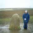
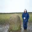
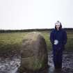
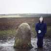
An erect stone is situated in an arable field 345m NNW of Gamekeepers Cottage (NJ80SW 40.01). It measures about 0.85m square at ground level and rises to a rounded head at a height of 1.5m. The stone is first depicted on the 2nd edition of the OS 6-inch map (Aberdeenshire, 1901, sheet lxxxv.NW) and it was probably erected as a cattle-rubbing stone sometime in the late-19th century.
Visited by RCAHMS (JRS, ATW), 13 February 1997.

