
Pricing Change
New pricing for orders of material from this site will come into place shortly. Charges for supply of digital images, digitisation on demand, prints and licensing will be altered.
Meadowheads, Forglen


Enclosure(S) (Period Unassigned), Pit(S) (Period Unassigned), Ring Ditch(S) (Period Unassigned)(Possible)
Site Name Meadowheads, Forglen
Classification Enclosure(S) (Period Unassigned), Pit(S) (Period Unassigned), Ring Ditch(S) (Period Unassigned)(Possible)
Canmore ID 19261
Site Number NJ75SW 16
NGR NJ 7075 5075
Datum OSGB36 - NGR
Permalink http://canmore.org.uk/site/19261


- Council Aberdeenshire
- Parish Forglen
- Former Region Grampian
- Former District Banff And Buchan
- Former County Banffshire
NJ75SW 16 7075 5075
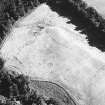
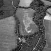
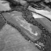
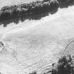
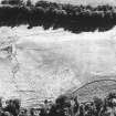
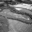
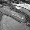
(Location cited as NJ 7078 5073). Air photography (AAS/78/06/13-17 flown 17 August 1978 and AAS/84/02/R4/3-6, flown 7 July 1984) has recorded cropmarks on a gentle slope at an altitude of 50m OD. They include rectilinear enclosures, pits and a large circular enclosure towards the NE of the field, and also a possible ring-ditch, a trapezoidal enclosure and indeterminate markings.
NMRS, MS/712/35.

