Cairnhall
Stone Circle (Neolithic) - (Bronze Age)
Site Name Cairnhall
Classification Stone Circle (Neolithic) - (Bronze Age)
Canmore ID 18572
Site Number NJ71NE 17
NGR NJ 7850 1759
Datum OSGB36 - NGR
Permalink http://canmore.org.uk/site/18572
- Council Aberdeenshire
- Parish Kintore
- Former Region Grampian
- Former District Gordon
- Former County Aberdeenshire
NJ71NE 17 7850 1759.
For stone circles at Broomend of Crichie (NJ 7792 1967), Fullerton (NJ 7839 1797), Hill of Tuack (NJ 7957 1544) and Castle Hill, Kintore (NJ 7939 1634), see NJ71NE 6, NJ71NE 14, NJ71NE 27, NJ71NE 32.00 respectively.
(NJ 7850 1759) Stone (NAT)
OS 6" map, Aberdeenshire, 2nd ed., (1928)
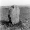
The remains of the circle at Cairnhall consisted of two stones, one standing, and the other prostrate; but by 1917 only the single standing stone remained.
F R Coles 1901; J Ritchie 1917.
All that remains of this stone circle is a single stone 1.5m high, 2.3m in girth, situated at NJ 7849 1759 in a contractor's yard near Cairnhall.
Revised at 1/2500.
Visited by OS (RD) 19 March 1964.
Nothing is now visible of this stone circle, the last stone having been removed some time after 1964.
Visited by RCAHMS (JRS, IF), 7 May 1996.


