
Following the launch of trove.scot in February 2025 we are now planning the retiral of some of our webservices. Canmore will be switched off on 24th June 2025. Information about the closure can be found on the HES website: Retiral of HES web services | Historic Environment Scotland
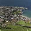
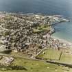
Banff, Bridge Road, Princess Royal Park


Park (20th Century), Recreation Ground (20th Century)
Site Name Banff, Bridge Road, Princess Royal Park
Classification Park (20th Century), Recreation Ground (20th Century)
Alternative Name(s) Banff Bridge
Canmore ID 115264
Site Number NJ66SE 99
NGR NJ 6926 6386
NGR Description Centred NJ 6926 6386
Datum OSGB36 - NGR
Permalink http://canmore.org.uk/site/115264


- Council Aberdeenshire
- Parish Banff
- Former Region Grampian
- Former District Banff And Buchan
- Former County Banffshire
NJ66SE 99 centred 6926 6386
Princess Royal Park [NAT] (name centred NJ 6926 6386)
OS (GIS) MasterMap, July 2009.

