
Rothiemay Castle, Laundry


Laundry (19th Century) - (20th Century)
Site Name Rothiemay Castle, Laundry
Classification Laundry (19th Century) - (20th Century)
Alternative Name(s) Rothiemay Castle Policies
Canmore ID 311008
Site Number NJ54NE 7.07
NGR NJ 55417 48587
NGR Description CENTRE OF SITE
Datum OSGB36 - NGR
Permalink http://canmore.org.uk/site/311008


- Council Moray
- Parish Rothiemay
- Former Region Grampian
- Former District Moray
- Former County Banffshire
For related sites see:
NJ54NE 7.00 NJ 55360 48459 Rothiemay Castle
NJ54NE 7.01 NJ 54807 48314 West Lodge
NJ54NE 7.02 NJ 55035 48276 Dovecot
NJ54NE 7.03 NJ 55122 48430 Kilnbarn
NJ54NE 7.04 NJ 55514 48168 Queen Mary's Bridge
NJ54NE 7.05 NJ 55099 48500 Mains of Rothiemay
NJ54NE 7.06 NJ 55514 48250 Kirktown of Rothiemay
NJ54NE 7.08 NJ 55444 48501 Manse
NJ54NE 7.09 NJ 55480 48432 St Peter's Well
The ruin of a washhouse is situated in the NE corner of Rothiemay Castle policies, butting the S wall of the causeway which defines the N and E boundaries of the castle grounds. The washhouse and causeway were built at the same time, between 1750 and 1752 (Duff House Papers, Special Libraries and Archives, University of Aberdeen, MS 3175/648). Water for the washhouse was provided through a stone channel built into the causeway and fed from an unknown source, above – probably a well in the adjacent field. The water supply to Rothiemay House/Castle was taken from a well approximately 800m to the N, but this may have been a later installation.
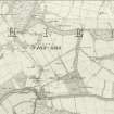
The washhouse building is still shown as roofed on the 1st Edition Ordnance Survey map (Banffshire, xv and xvii, surveyed 1867, published 1871). The adjacent manse building (NJ54NE 08) became the laundry in the 19th century.
For further details regarding this and neighbouring sites lying within the policies of Rothiemay Castle, see the Kirkton of Rothiemay Survey Report, linked to this record.
Information from William Reid, May 2011.
Field Visit (2009 - 2011)
Photographic survey.
The ruin of a washhouse is situated in the NE corner of Rothiemay Castle policies, butting the S wall of the causeway which defines the N and E boundaries of the castle grounds. The washhouse and causeway were built at the same time, between 1750 and 1752 (Duff House Papers, Special Libraries and Archives, University of Aberdeen, MS 3175/648). Water for the washhouse was provided through a stone channel built into the causeway and fed from an unknown source, above – probably a well in the adjacent field. The water supply to Rothiemay House/Castle was taken from a well approximately 800m to the N, but this may have been a later installation.
The washhouse building is still shown as roofed on the 1st Edition Ordnance Survey map (Banffshire, xv and xvii, surveyed 1867, published 1871). The adjacent manse building (NJ54NE 08) became the laundry in the 19th century.
For further details regarding this and neighbouring sites lying within the policies of Rothiemay Castle, see the Kirkton of Rothiemay Survey Report, linked to this record.
Information from William Reid, May 2011.

