
Kinbattoch


Moated Site (Medieval)
Site Name Kinbattoch
Classification Moated Site (Medieval)
Alternative Name(s) Kinbattock; Towie; Woodside
Canmore ID 17166
Site Number NJ41SW 7
NGR NJ 4285 1138
Datum OSGB36 - NGR
Permalink http://canmore.org.uk/site/17166


- Council Aberdeenshire
- Parish Towie
- Former Region Grampian
- Former District Gordon
- Former County Aberdeenshire
NJ41SW 7 4285 1138
See also NJ41SW 15.
(NJ 4285 1138) Fort (NR) (Fosse) (NR)
OS 6" map, Aberdeenshire, 2nd ed., (1902)
A quandrangular little fort, the fosse is levelled in the SE and upon the NE is a cottage and garden. It was 15-20 feet deep. The New Statistical Account states that it was apparently water-filled; Keith notes it as a pre-Norman motte.
NSA 1845; Name Book 1866; A Keith 1935.
The mutilated remains of a homestead moat considerably reduced and spread by the plough. The ditch is best preserved in the NW where it measures about 16.0 metres wide and about 2.5 metres deep.
Re-surveyed at 1/2500.
Visited by OS (R L) 27 August 1968.
This site is listed in an Atlas of Scottish History (McNeill and MacQueen 1996) as a moated site.
Information from RCAHMS (DE), September 1997.
(Name cited as Woodside). Thius monument is situated at an altitude of 290m OD.
NMRS, MS/712/46.
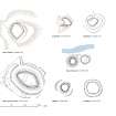
The remains of this moated site are situated in a cultivated field 430m S of the farmhouse at Kinbattoch (NJ41SW 175); most of it is regularly ploughed, but the N corner is overlain by the garden of a cottage and a small stand of trees. Subrectangular on plan, the interior measures about 21m from NE to SW by 14m transversely within two banks with a medial ditch. They are best preserved on the NE and E, the inner bank measuring up to 6m in thickness and 0.5m in height, the ditch about 15m in breadth, and the outer bank 10m in thickness, though their profiles have been eroded by the plough. On the NW the outer bank is overlain by the track leading to Kinbattoch farmsteading, and the ditch at the N and W corners has been partly filled in.
Visited by RCAHMS (JRS), 26 April 2000.
Field Visit (26 April 2000)
The remains of this moated site are situated in a cultivated field 430m S of the farmhouse at Kinbattoch (NJ41SW 175); most of it is regularly ploughed, but the N corner is overlain by the garden of a cottage and a small stand of trees. Subrectangular on plan, the interior measures about 21m from NE to SW by 14m transversely within two banks with a medial ditch. They are best preserved on the NE and E, the inner bank measuring up to 6m in thickness and 0.5m in height, the ditch about 15m in breadth, and the outer bank 10m in thickness, though their profiles have been eroded by the plough. On the NW the outer bank is overlain by the track leading to Kinbattoch farmsteading, and the ditch at the N and W corners has been partly filled in.
Visited by RCAHMS (JRS), 26 April 2000.
Measured Survey (26 April 2000)
RCAHMS surveyed the moated site at Kinballoch at a scale of 1:500. The pencil drawing was scanned and then redrawn using graphic vector software at the smaller scale of 1:1250, before publication in illustration of seven medieval sites in RCAHMS 2007, Fig 8.11.

